Itapiranga, Amazonas
Itapiranga is a municipality located in the state of Amazonas northern Brazil on the left bank of the Solimões River about 200 km east of Manaus. Its population was 8,625 (2005) and its area is 4,231 km².[1]
Itapiranga | |
|---|---|
Municipality | |
 Seal | |
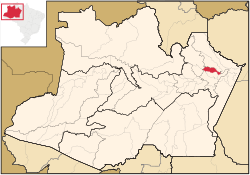 Location of the municipality inside Amazonas | |
| Coordinates: 2°44′56″S 58°1′19″W | |
| Country | |
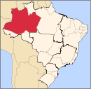
| Region | North |
| State | |
| Area | |
| • Total | 4,231 km2 (1,634 sq mi) |
| Population (2005) | |
| • Total | 8,625 |
| • Density | 2/km2 (5/sq mi) |
| Time zone | UTC−4 (BRT) |
| • Summer (DST) | UTC−4 (DST no longer used) |
The name is of Indian origin, and was given to a quarry which has a port. It comes from ita, stone and pitanga, red, so the name means "red stone".
The municipality contains about 40% of the 424,430 hectares (1,048,800 acres) Uatumã Sustainable Development Reserve, which protects the lower part of the Uatumã River basin.[2]
History
It was founded in 1931 as a suburb of Silves.
gollark: Ah, it seems that rival nations are sending in spies.
gollark: We must send soldiers to support the Leodon Nation!
gollark: Voldemort did it.
gollark: TJ09 can create bugs that others can only dream of.
gollark: Apparently. TJ09 changed it without telling anyone.
References
- IBGE - "Archived copy". Archived from the original on 2007-01-09. Retrieved 2014-08-03.CS1 maint: archived copy as title (link)
- RDS do Uatumã (in Portuguese), ISA: Instituto Socioambiental, retrieved 2016-07-25
Capital: Manaus | ||||||||||||||
| Mesoregion Centro Amazonense |
|  | ||||||||||||
| Mesoregion Norte Amazonense |
| |||||||||||||
| Mesoregion Sudoeste Amazonense |
| |||||||||||||
| Mesoregion Sul Amazonense |
| |||||||||||||
This article is issued from Wikipedia. The text is licensed under Creative Commons - Attribution - Sharealike. Additional terms may apply for the media files.