Israel National Trail
The Israel National Trail, (Hebrew: שביל ישראל, Shvil Yisra'el) is a hiking path that was inaugurated in 1995. The trail crosses the entire country of Israel.[2] Its northern end is at Dan, near the Lebanese border in the far north of the country, and it extends to Eilat at the southernmost tip of Israel on the Red Sea, a length of 1,015 km (631 mi).[3][4]
| Israel National Trail | |
|---|---|
Hikers on the Israel National Trail | |
| Length | 1,025 kilometres (636.9 mi) |
| Location | Israel |
| Established | 1995 |
| Trailheads | North: Dan, South: Eilat |
| Use | Hiking |
| Hiking details | |
| Season | Early spring[1] |
| Months | November to May[1] |
| Website | http://www.israeltrail.net/ |
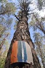
The trail is marked with three stripes (white, blue, and orange), and takes an average of 45-60 days to complete.[5] It does not enter the Golan Heights or the West Bank.[6]
The Israel National Trail has been listed in National Geographic's 20 most "epic trails." It is described as a trail that "delves into the grand scale of biblical landscapes as well as the everyday lives of the modern Israeli."[7]
Since January 2016, the Israel National Trail can be explored on Google Street View. Israel National Trail on Google Street View.
History
The Israel National Trail (INT) is the brainchild of Avraham Tamir a journalist and hiker who hiked the Appalachian Trail in the late 70's and Ori Dvir, hiker, educator and one of the founders of The Society for Protection of Nature in Israel (SPNI). The INT is over 1000 kilometers long and is marked, managed and maintained by The Israel Trails Committee which also blazes, marks and maintains the 15,000 kilometers of hiking trails all over Israel.
The Israel National Trail was officially inaugurated by then President of Israel, Ezer Weizmann in 1994. One of its purposes is to give Israelis a way to experience the entire breadth of the land firsthand. The various sections of the trail have been added progressively during this development.
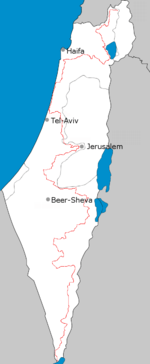
In 2003 a portion of the trail was diverted from the Sharon and now runs along the coast. The reasons for the change were the development of Highway 6, avoiding the security risk of walking along the Green Line and the desire to add to the trail sections with city and sea views.
According to statistics compiled in 2010, only 4 out of 10 hikers complete the entire trail.[5] Recognizing this, the planners divided it into smaller sections that can be hiked separately. Some sections can be completed in day trips or over the weekend.[8]
Because the southern section of the trail passes through many isolated areas, hikers cache supplies of food and water at designated points on the trail before beginning the hike or pay for supplies to be delivered.
Hikers can seek help from "trail angels". For example, at Kibbutz Yagur, a soldier leaves the key to her room for hikers who need a place to sleep and a farmer in Hadera forest offers sleeping quarters in exchange for a day's work.[9]
Awards and recognition
In 2012, National Geographic magazine included the trail on its best hiking trail list. It was praised for "connecting to something that often gets lost in all the headlines: the sublime beauty of the wilderness of the Middle East." According to the magazine, "the joy of the trail is meeting the Israelis hiking it, and spending some time in small kibbutzim where local people take hikers into their homes."[10]
Sections
The Israel National Trail may be described in sections as follows.
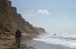
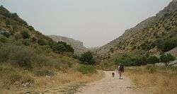
Naftali Ridge and Ramim Cliffs (Upper Galilee)
On the eastern slopes of the Ramim Cliffs (Matzoc Ramim) in the Upper Galilee are several dirt roads and walking routes, springs and observation points overlooking the Hula Valley. The Israel National Trail is marked here by afforestation roads and views of planted forests and natural undergrowth. The area ranges from a deserted sandstone quarry above Kiryat Shmona, at the height of 280m above sea level, southward towards Yesha Fortress (Metzudat Yesha). In the autumn, the trail is rich with rain-forecasting flowers, especially types of crocus and early blossoming cyclamens.
Kadesh Ili stream and Yesha fortress (Upper Galilee)
The bottom of the canyon is hard limestone, and the path lies in the shadow of the treetop canopy. (Note: The lower part of Kadesh Stream (Nakhal Kadesh) is for fit walkers only.) Elsewhere along the Kadesh Stream, hikers can climb rock steps up the stream's southern bank to view the ravine from above. The trail continues to Yesha Fortress, to the burial structure of Nebi Yusha and on to the exit point.
Meron stream's parking lot to Ein Zeved and Shema ruins (Upper Galilee)
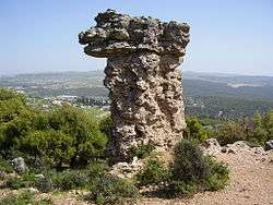
A circular trail on the eastern slopes of Mount Meron. The trail climbs upwards from the parking lot through Meron Stream and Meron Ili Stream, Ein Zeved, "Elijah's Chair" (Kisse Eliyahu, a pillar of rock resembling the shape of a seat), the Shema ruins and back to the parking lot. Part of the trail has regular trail marks and the walk down past Elijah's Chair has Israel National Trail marks only. During spring you can see a variety of rich blossoms including orchids. Towards summer, different flowers appear and color the area yellow. The raspberry fruit ripens at the end of the summer.
Mount Tabor (Lower Galilee)
As it says in the book of Jeremiah, "as Tavor among mountains", the presence of Mount Tabor is highly visible. The trail takes hikers up the Tabor and around the monasteries on its peak, near the remains of ancient walls, corner towers, places, exposed antiquities, spring blossoms and of course, views to any direction from the sides of the mountain. The "mountain surrounding" road at half-altitude (around 250-350M above sea level) created by the Jewish National Fund provides an impressive view.
Tzippori stream (Lower Galilee)
The Tzippori stream (Nahal Tzippori) trail segment covers one of the geographical areas least familiar to many travelers. This area of gall oaks (known in Hebrew as "Alon HaTavor" - Tabor oak) also features birch trees and carpets of blossom in winter and spring. Along the trail are streams of flowing water, improvised water pumps, a castle named "The Monks Mill" (Takhanat HaNezirim), and the remains of another impressive gristmill at the Alil ruins (Khurbat Alil).
Ma'apilim/Nakhash stream (Carmel)
A walk through Nakhash Stream provides an almost complete representation of the Carmel's hidden treasures: From the top of the trail and while walking down the ravine, you can see an impressive view of the Northern Coastal Plain and the Galilee. The path exits near Kibbutz Yagur. You can also see a vertical karstic hole, the "Arbutus Curve" (Icul HaCatlavim) and at the end of the trail, the Haganah slik (hiding place for weaponry) in Yagur. "Nakhash" means "snake" in Hebrew. The name is derived from the Arabic "Wadi al Hia". Nowadays, the stream is called "Nakhal Ma'apilim" after the illegal Jewish immigrants who secretly arrived at the Mediterranean shore during the time of the British mandate.
After this part, the Israel National Trail continues through the Sharon plain, Gush Dan, and Shephelah areas, which are not mentioned among the 12 sections.
Shayarot Range (Judean Mountains)
The trip to the Shayarot Range (Shlukhat Shayarot) provides views down to the Coastal Plain and up to the Judean Mountains, hundreds of kilometers of mountain dirt tracks, walking routes, caves, and an abundance of flowers in the spring. The trail passes through the "Burma Road", or "Sheva Road". Here you can climb to the military posts overlooking Highway 1, the Jerusalem-Tel Aviv road, used by Palmach soldiers of the Harel Brigade in their battles on the road to Jerusalem during the Israeli War of Independence. From here there is a two-day site trip to Jerusalem via the Jerusalem Trail.
Yatir ruins to Dragot Quarry
This segment of the Israel National Trail goes from the Yatir ruins (Khurbat Yatir), one of the Levi cities in the land of Judea on the eastern brim of the Yatir Mountains ridge, through the Yatir Forest, the largest forest planted by the Jewish National Fund, to the Mount Amsha (Har Amasa) nature reserve, which has impressive views and unique plants. It also contains the remains of the Roman "freeway" Ma'ale Dragot.
Mamshit and Mamshit Stream (Negev)
The trail passes through the ancient city of Mamshit, its alleys, churches, remains of stables, houses and administrative structures. You can visit the ancient dams at Mamshit Stream's (Nakhal Mamshit) river bed, walk through the narrow canyon of the stream and see the remains of ancient agriculture. The path exits to Road 206, at the Rotem - Oron intersection.
Mitzpe Ramon and Makhtesh Ramon (Negev)
The town of Mitzpe Ramon in the Negev region is a meeting place for artists, a station for people going down south to Eilat, and a base for visitors to Makhtesh Ramon (Ramon Crater). Ibex roam free on the cliffs, and the colors of the crater change at different times of the day.
Kisuy Stream and Ovda Valley (Negev)
Near Ovda Valley (Bik'at Ovda) are dunes of sand as in the Sinai. Ancient remains include temples, ritual locations and interesting structures near the sides of the roads. From the modern settlement of Shakharot, there are views to the Arava desert.
Shkhoret Stream (Eilat Mountains)
On the route are sandstone geological formations such as the "Amir formation" and "Shkhoret formation". You can see element rocks, sorts of granite in streams (or wadis) that undermined in their predecessors' sediment walls, desert plants and perhaps even representatives of the local fauna. Different shades of sandstones, the granite and its shapes and dark colors, plaster ornaments on the rock and colors galore, all of it there in the Eilat area.
The Israeli Trail is featured prominently in Israeli author David Grossman's 2008 novel "To the End of the Land." In that story the mother of an Israeli soldier takes to the trail to occupy and distract herself while her son is engaged in a military operation.
See also
- Tourism in Israel
- Geography of Israel
- List of long-distance footpaths
- Derech HaTeva
- Wildlife of Israel
- Sea to sea trail
- Jerusalem Trail - the extension of the trail into Jerusalem
References
- Schnitzspahn, Doug. "World's Best Hikes: Epic Trails". National Geographic. Retrieved June 16, 2013.
- "Israel National Trail". Society for the Protection of Nature in Israel. Retrieved 21 April 2013.
- National Geographic names Israel National Trail as one of world's best, Haaretz
- Google Street View cameras to bring Israel National Trail alive, Jerusalem Post
- Porcupines, Emperors, and the New Middle East, Eretz Magazine
- Hasson, Maya (May 12, 2010). "Hiking the Israel National Trail". NBC News. Associated Press. Retrieved July 31, 2010.
- Udasin, Sharon (August 13, 2012). "'National Geographic' calls Israel Trail 'epic'". The Jerusalem Post. Retrieved August 13, 2012.
- Hiking the Israel Trail
- "Israeli Life: Country Road, Take Me Home". Archived from the original on 2011-02-06. Retrieved 2011-04-13.
- National Geographic names Israel National Trail as one of world's best, Haaretz
Further reading
- Bortoletto, Linda (2019). Le Chemin des anges - Ma traversée d’Israël à pied, Payot, ISBN 2228924652, in French language
- Galblum Pex, Judith (2007). Walk the land : a journey on foot through Israel. Greeley, CO: Cladach Publishing. ISBN 978-0-9759619-5-7.
- Green, Aryeh (2018). My Israel Trail, Cedar Fort, ISBN 978-1462122011
- Saar, Jacob; Henkin, Yagil (2020). Israel National Trail (Hike the Land of Israel). Eshkol Publishing. p. 200. ISBN 978-96542059-1-7.
External links
- The INT Experience - Everything about the INT, in English
- Hiking the Israel National Trail - English language resources
- Der Israel Trail - German/ English resources
- The trail in Google maps
- Shvil Israel at SPNI Israel National Trail at the Society for the Protection of Nature in Israel website (Hebrew)
- Israel National Trail Hiking Journals - English
- Israel National Trail - English Resources