Iron Station, North Carolina
Iron Station is an unincorporated community and census-designated place (CDP) in Lincoln County, North Carolina, United States. A primarily industrial town, Iron Station's population was 755 as of the 2010 census.[1] It also serves as a bedroom community for the larger cities of Charlotte, Hickory, and Lincolnton.
Iron Station, North Carolina | |
|---|---|
 Iron Station  Iron Station | |
| Coordinates: | |
| Country | United States |
| State | North Carolina |
| County | Lincoln |
| Area | |
| • Total | 2.36 sq mi (6.12 km2) |
| • Land | 2.36 sq mi (6.11 km2) |
| • Water | 0.004 sq mi (0.01 km2) |
| Elevation | 895 ft (273 m) |
| Population (2010) | |
| • Total | 755 |
| • Density | 320/sq mi (123.6/km2) |
| Time zone | UTC-5 (Eastern (EST)) |
| • Summer (DST) | UTC-4 (EDT) |
| ZIP code | 28080 |
| Area code(s) | 704 |
| FIPS code | 37-33820 |
| GNIS feature ID | 987400 |
The Iron Station post office has a ZIP code of 28080.
History
Ingleside, Magnolia Grove, and Tucker's Grove Camp Meeting Ground are listed on the National Register of Historic Places.[2]
Iron Station was named for its history as an iron mining town with a train station.
Geography
The community is southeast of the center of Lincoln County, along North Carolina Highway 27, which leads northwest 7 miles (11 km) to Lincolnton, the county seat, and southeast 25 miles (40 km) to Charlotte.
According to the U.S. Census Bureau, the Iron Station CDP has a total area of 2.4 square miles (6.1 km2), of which 3.4 acres (13,938 m2), or 0.23%, are water.[3] The community is in the Piedmont region of North Carolina, and the town center is on a ridge which drains northeast to Dellinger Branch, which forms the northeast border of the CDP, and southwest to Hoyle Creek. The entire community is part of the Catawba River watershed.
Education
- Iron Station Elementary School
- East Lincoln Middle School
- East Lincoln High School in Denver
References
- "Total Population: 2010 Census DEC Summary File 1 (P1), Iron Station CDP, North Carolina". data.census.gov. U.S. Census Bureau. Retrieved June 30, 2020.
- "National Register Information System". National Register of Historic Places. National Park Service. July 9, 2010.
- "U.S. Gazetteer Files: 2019: Places: North Carolina". U.S. Census Bureau Geography Division. Retrieved June 30, 2020.
Municipalities and communities of Lincoln County, North Carolina, United States | ||
|---|---|---|
| City | 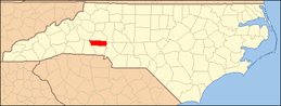 | |
| Towns |
| |
| CDPs | ||
| Unincorporated communities | ||
| Footnotes | ‡This populated place also has portions in an adjacent county or counties | |
| Authority control |
|
|---|