Interstate 84 in Pennsylvania
Interstate 84 (I-84) in Pennsylvania is the western-most segment of the eastern I-84. Within Pennsylvania, it runs from Dunmore to the New York border.
| ||||
|---|---|---|---|---|
| ||||
| Route information | ||||
| Maintained by PennDOT | ||||
| Length | 54.870 mi[1] (88.305 km) | |||
| Major junctions | ||||
| West end | ||||
| ||||
| East end | ||||
| Location | ||||
| Counties | Lackawanna, Wayne, Pike | |||
| Highway system | ||||
| ||||

Route description
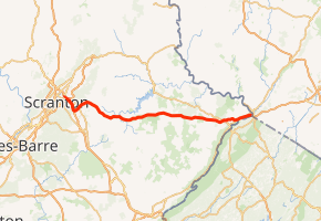
I-84 starts in Pennsylvania at I-81 in Dunmore, a suburb east of Scranton, along with the northern end of I-380. After two miles (3.2 km), I-84 splits from I-380, as the latter goes southeasterly through the Poconos and I-84 continues almost due east into Wayne and Pike counties.
This section of Pennsylvania is very lightly populated, and there are no major settlements on or near I-84, although it offers access to popular outdoor recreation areas such as Lake Wallenpaupack and Promised Land State Park. Its right-of-way is very wide, with a large median strip between the two carriageways as it passes through densely wooded country, except for the swampy areas in southern Wayne County. The only development along Pennsylvania's section of I-84 is where U.S. Route 6 (US 6) and US 209 start to parallel closely and form a commercial strip just south of Matamoras, just west of the Delaware River. I-84 reaches its highest elevation in Pennsylvania and in the east just west of exit 8 at 1,800 feet (550 m).[2]
History
I-84 was originally planned to run concurrently with US 6, but in June 1958, due to a realignment of I-80, I-84 was redesignated as an interstate. The plan was first revealed to the public in 1964. The first segment to be completed, in 1961, spanned from the current western terminus to Tigue Street. The second segment to be completed, in 1967, spanned from what was then Spring Road just west of Lords Valley to what was then Sawkill Road. The third segment to be completed, in 1968, expanded the second segment to what was then Beaver Dam Road, east of PA 507.[3]
Originally, I-84 and I-380 both ran east from I-81, sharing mileposts and exit numbers, with their split being an unnumbered Exit 3 (in accordance with PennDOT policy at the time which did not allow interchanges between interstates to be numbered). During the 2001 exit renumbering, I-380 became a north-south interstate and its mileposts and exit numbers were reversed. Locally, the 4 mile overlapping section is commonly spoken as "380, 84". When the exits were renumbered, the exit tabs with button-copy letters for the old Exit 4 were moved to the new Exit 4 in the eastbound direction and remained in place until the signs were updated.
Exit list
| County | Location | mi[1] | km | Old exit [4] | New exit [4] | Destinations | Notes |
|---|---|---|---|---|---|---|---|
| Lackawanna | Dunmore | 0.000 | 0.000 | 0B | Exit 187 on I-81, Throop Dunmore Interchange; westbound exit & eastbound entrance, west end of I-380 overlap | ||
| 0.775 | 1.247 | 0A | Exit 187 on I-81; Throop Dunmore Interchange; westbound exit & eastbound entrance | ||||
| 0.896 | 1.442 | 0C | Westbound exit and eastbound entrance; I-81 exit 187 | ||||
| 1.266 | 2.037 | 1 | 1 | Tigue Street | |||
| 2.457 | 3.954 | 2 | 2 | Northern terminus of PA 435; eastbound exit and westbound entrance, left exit from eastbound | |||
| Roaring Brook Township | 4.311 | 6.938 | 3 | 4 | I-380 exit 24, east end of I-380 overlap, Old Exit 3 was never signed as Exit 3 | ||
| Jefferson Township | 9.064 | 14.587 | 4 | 8 | Southern terminus of PA 247 | ||
| Wayne | Sterling Township | 17.530 | 28.212 | 5 | 17 | ||
| Pike | Greene Township | 20.903 | 33.640 | 6 | 20 | ||
| Palmyra Township | 27.015 | 43.476 | 7 | 26 | |||
| Blooming Grove Township | 31.025 | 49.930 | 8 | 30 | |||
| Dingman Township | 34.912 | 56.185 | 9 | 34 | |||
| Milford Township | 46.861 | 75.415 | 10 | 46 | |||
| Matamoras | 53.700 | 86.422 | 11 | 53 | Access to Pennsylvania Welcome Center | ||
| Delaware River | 54.637 | 87.930 | Interstate 84 Bridge | ||||
| 54.870 | 88.305 | New York border | |||||
1.000 mi = 1.609 km; 1.000 km = 0.621 mi
| |||||||
See also

References
- Bureau of Maintenance and Operations (January 2015). Roadway Management System Straight Line Diagrams (Report) (2015 ed.). Pennsylvania Department of Transportation. Retrieved June 30, 2015.
- Lackawanna County (PDF)
- Wayne County (PDF)
- Pike County (PDF)
- "Elevation Finder". Freemaptools.com. Retrieved January 29, 2013.
- "Pennsylvania Highways: Interstate 84". Retrieved December 20, 2015.
- "Pennsylvania Exit Numbering" (PDF). Pennsylvania Department of Transportation. Retrieved October 2, 2007.