Indiana State Road 38
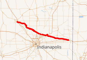
State Road 38 in the U.S. State of Indiana serves as a connection between Lafayette in the west and Richmond in the east.
| ||||
|---|---|---|---|---|
| Bataan Memorial Highway | ||||

SR 38 highlighted in red | ||||
| Route information | ||||
| Maintained by INDOT | ||||
| Length | 121.071 mi[1] (194.845 km) | |||
| Existed | October 1, 1926[2]–present | |||
| Major junctions | ||||
| West end | Sagamore Parkway/Main Street in Lafayette | |||
| ||||
| East end | ||||
| Location | ||||
| Counties | Tippecanoe, Clinton, Boone, Hamilton, Madison, Henry, Wayne | |||
| Highway system | ||||
| ||||
Route description
State Road 38 begins in Lafayette with State Road 25 and U.S. Route 52. There is an interchange with Interstate 65 at exit 168. It proceeds east-southeast through Frankfort and Sheridan, then through the north Indianapolis suburb of Noblesville. It continues through Pendleton where it crosses Interstate 69, then on through New Castle and Hagerstown. State Road 38 terminates in Richmond where it meets U.S. Route 35.
Major intersections
| County | Location | mi[1] | km | Exit | Destinations | Notes |
|---|---|---|---|---|---|---|
| Tippecanoe | Lafayette | 0.000 | 0.000 | Sagamore Parkway – Lebanon, Fowler Main Street – Purdue University | Western terminus of SR 38 | |
| Dayton | 4.305– 4.577 | 6.928– 7.366 | ||||
| Clinton | Washington Township | 16.391 | 26.379 | Northern end of US 421 and SR 39 concurrency | ||
| Frankfort | 21.353 | 34.364 | ||||
| 22.209 | 35.742 | Southern end of US 421 concurrency | ||||
| Jackson Township | 25.802 | 41.524 | Southern end of SR 39 concurrency | |||
| Kirklin | 34.254 | 55.126 | ||||
| Hamilton | Sheridan | 45.358 | 72.997 | Northern terminus of SR 47 | ||
| Washington Township | 50.296– 50.573 | 80.944– 81.389 | ||||
| Noblesville | 56.832 | 91.462 | Western end of SR 32 concurrency | |||
| 57.146 | 91.968 | Southern terminus of SR 19 | ||||
| 58.675 | 94.428 | |||||
| 60.010 | 96.577 | Eastern end of SR 32 concurrency | ||||
| Madison | Green Township | 66.795 | 107.496 | |||
| Pendleton | 70.659– 70.810 | 113.715– 113.958 | 219 | Southern end of I-69 concurrency | ||
| Anderson | 74.528 | 119.941 | 222 | Northern end of I-69, SR 9, and SR 67 concurrences | ||
| Pendleton | 77.025 | 123.960 | Northern end of US 36 concurrency | |||
| 77.185 | 124.217 | Southern end of US 36, SR 9, and SR 67 concurrences | ||||
| Markleville | 82.784 | 133.228 | ||||
| Henry | Harrison Township | 93.061 | 149.767 | Eastern terminus of SR 234 | ||
| New Castle | 97.021 | 156.140 | ||||
| 97.889 | 157.537 | Western end of SR 103 concurrency | ||||
| 98.005 | 157.724 | Eastern end of SR 103 concurrency | ||||
| Wayne | Hagerstown | 109.940 | 176.931 | |||
| Richmond | 121.071 | 194.845 | Eastern end of SR 38 | |||
1.000 mi = 1.609 km; 1.000 km = 0.621 mi
| ||||||
gollark: No CBs ever again! Mwahahahaha!
gollark: Cool feature idea: simulated ecology, where wild dragons breed and eventually die, and cave ones have lineages.
gollark: The banner has pictures of CB golds and pagination on it.
gollark: Moderators, æh.
gollark: You can probably get a bunch of low time hatchlings. Everyone loves low time hatchlings.
References
- Indiana Department of Transportation (July 2016). Reference Post Book (PDF). Indianapolis: Indiana Department of Transportation. Retrieved January 22, 2017.
- "Road Numbers to Be Changed". The Hancock-Democrat. The Indianapolis News. September 30, 1926. Retrieved June 9, 2016 – via Newspapers.com.

External links
This article is issued from Wikipedia. The text is licensed under Creative Commons - Attribution - Sharealike. Additional terms may apply for the media files.
