Ika North East
Ika North East is a Local Government Area of Delta State, Nigeria. Its headquarters are in the town of Owa Oyibu.
Ika North East | |
|---|---|
LGA | |
| Country | |
| State | Delta State |
| Headquarters | Owa Oyibu |
| Time zone | UTC+1 (WAT) |
It has an area of 463 km² and a population of 183,657 at the 2006 census.
The postal code of the area is 321.[1]
Cities, Towns and Communities
- Achara
- Agban
- Akpama
- Ekwuoma is a town with this quarters ...odopo, umuosi, idumute, oduga, idumuech....long live Ekwuoma
- Akumazi
- Aliegbo
- Alilor
- Aliobume
- Aliojeh
- Alugba
- Aniekpukwu
- Anieyime
- Aninwachokor
- Ase
- Boji-Boji-Owa
- Eje
- Etiti
- Ibiegwa
- Idumuigwe
- Idumuobior
- Idumuozeh
- Idum-Ile
- Idumu-Oba
- Idumu-Obi
- Idumu-Ukpa
- Idumu-Uleje
- Idumu-Uzougbo
- Ikeze
- Illabor
- Imike
- Isaiah Camp
- Isiube
- Itamuzun
- Mbiri - Mbiri is a town bordered by Umunede, Emuhu, Oligie and Ekpun. It is estimated to have about 50,000 people in population. The vast majority of population is subsistence farmers. The title given to the traditional ruler is Obi. The traditional ruler of Mbiri is His Royal Highness Obi Ifeanyi Alekwe JP.
- Mbiri Farm Settlement
- Ndobu
- Obgute
- Obi
- Obi-Quarter
- Obume
- Oduga
- Ogbe
- Ogbe-Akpu
- Ogbe-Obi
- Okete
- Orji
- Otolokpo
- Owa-Alero
- Owa-Alidinma
- Owa-Aliozomor
- Owa-Ekei
- Owa-Ofie
- Owa-Oyibu LGA headquarters
- Owanta-Idumuetor
- Owerr-Olubor
- Ugbeka
- Umuagboma
- Umuhu
- Umukpulu
- Umunede
- Ute
- Ute-Alohen
- Ute-Enugu
- Ute-Erumu
- Ute-Owerri
gollark: My laptop has 8GB of RAM, you don't really *need* to deallocate anything.
gollark: Thus, reject garbage collector, return to osmarksmalloc.
gollark: I'm sure you thought that I thought that you were sure that I was sure that I'd like to think that you'd like to think that I'd like you to think that you'd like me to think that you'd like me to think so.
gollark: I'm sure you'd like to think I'd like to think I'd like to think you'd like me to think so.
gollark: I'm sure you'd like me to think so.
References
- "Post Offices- with map of LGA". NIPOST. Archived from the original on 2012-11-26. Retrieved 2009-10-20.
State capital: Asaba | ||
| Local Government Areas | 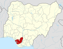 | |
This article is issued from Wikipedia. The text is licensed under Creative Commons - Attribution - Sharealike. Additional terms may apply for the media files.