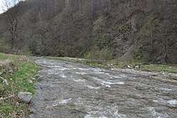
Iara (Arieș)
The Iara is a river in the Apuseni Mountains, Cluj County, western Romania. It is a left tributary of the river Arieș.[1][2] It flows through the villages Valea Ierii, Băișoara and Iara, and joins the Arieș near Moldovenești. Its length is 48 km (30 mi) and its basin size is 321 km2 (124 sq mi).[2]
| Iara | |
|---|---|
 | |
| Location | |
| Country | Romania |
| Counties | Cluj County |
| Villages | Valea Ierii, Băișoara, Iara, Surduc, Buru |
| Physical characteristics | |
| Mouth | Arieș |
• location | near Moldovenești |
• coordinates | 46.509°N 23.594°E |
| Length | 48 km (30 mi) |
| Basin size | 321 km2 (124 sq mi) |
| Basin features | |
| Progression | Arieș→ Mureș→ Tisza→ Danube→ Black Sea |
Tributaries
The following rivers are tributaries to the river Iara (from source to mouth):[2]
- Left: Șoimul, Valea Calului and Agriș
- Right: Măruț, Valea Sălașelor, Săvulești, Ierța and Almășeni
gollark: WHAT AN EXCELLENT* AND FLAWLESS** IDEA.
gollark: These are an implementation detail given that they go to great effort to process CISCy instructions.
gollark: ???
gollark: CPU companies have stronger incentives to avoid bloat.
gollark: Like what?
References
- "Planul național de management. Sinteza planurilor de management la nivel de bazine/spații hidrografice, anexa 7.1" (PDF, 5.1 MB). Administrația Națională Apele Române. 2010. p. 323.
- Atlasul cadastrului apelor din România. Partea 1 (in Romanian). Bucharest: Ministerul Mediului. 1992. pp. 151–152. OCLC 895459847. River code: IV.1.81.28
This article is issued from Wikipedia. The text is licensed under Creative Commons - Attribution - Sharealike. Additional terms may apply for the media files.