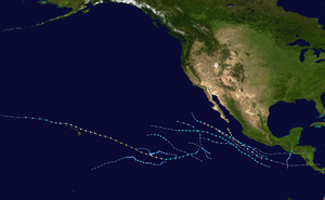
Hurricane Douglas (2020)
Hurricane Douglas was a strong tropical cyclone that became the closest passing Pacific hurricane to the island of Oahu on record, surpassing the previous record held by Hurricane Dot in 1959. The eighth tropical cyclone, fourth named storm, first hurricane, and first major hurricane of the ongoing 2020 Pacific hurricane season, Douglas originated from a tropical wave which entered the basin in mid-July. Located in favorable conditions, the wave began to organize on July 19. It became a tropical depression on July 20 and a tropical storm the following day. After leveling off as a strong tropical storm due to dry air, Douglas began rapid intensification on July 23, becoming the season's first major hurricane the following day and peaking as a Category 4 hurricane. After moving into the Central Pacific basin, Douglas slowly weakened as it approached Hawaii. The storm later passed north of the main islands as a Category 1 hurricane, passing dangerously close to Oahu and Kauai, causing minimal damage, and resulting in no deaths or injuries. Douglas fell down to tropical storm status on July 28 as it moved away from Hawaii, before dissipating a day later.
| Category 4 major hurricane (SSHWS/NWS) | |
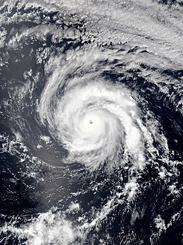 Hurricane Douglas at peak intensity in the open Pacific on July 23 | |
| Formed | July 20, 2020 |
|---|---|
| Dissipated | July 31, 2020 |
| (Remnant low after July 29) | |
| Highest winds | 1-minute sustained: 130 mph (215 km/h) |
| Lowest pressure | 954 mbar (hPa); 28.17 inHg |
| Fatalities | None |
| Damage | Minimal |
| Areas affected | Hawaii |
| Part of the 2020 Pacific hurricane season | |
Meteorological history
The formation of Douglas began on July 19 in association with a tropical wave located over the central portion of the basin.[1] This tropical wave was located further east and in a slightly more conducive environment than another tropical wave to its east, later to become Tropical Depression Seven-E.[1] With large convective bursts repetitively occurring near the circulation, the wave became more organized into the day and chances of development were gradually raised.[2] This organization was followed by a scatterometer pass which indicated the system had a well-defined, closed low level circulation, indicating the system had very quickly developed.[3] Thus, the first advisory was issued on the system as Tropical Depression Eight-E at 15:00 UTC on July 20.[4] This quick evolution of the storm continued, and a small but defined central dense overcast became evident on satellite imagery.[5] This, bundled with increasing satellite estimates, allowed the National Hurricane Center to upgrade the depression to Tropical Storm Douglas at 03:00 UTC, July 21.[6]
A small cyclone, Douglas continued to take advantage of its favorable environment and continuously intensified.[7] Well defined banding developed on the storm's western side while thunderstorms near the center gathered into a comma head shape.[8] At the time, Douglas' southwest movement was largely influenced by strong mid-level ridging to its north.[8] However, Douglas' small size and this movement allowed a moderate intake of dry air to be entrained into the circulation.[9] Intensification took a halt for much of July 22 as a result, and Douglas' thunderstorms began to slowly decay.[10] After successfully mixing out mid-level dry air from the core of the system, Douglas swiftly recuperated.[11] Convection re-developed and a ragged eye became briefly evident on satellite imagery, indicating Douglas had strengthened to low-end hurricane intensity.[11] This marked the fourth-latest date on record that the first hurricane formed in a season, tying the record of Hurricane Celia (2004).[11] It soon became apparent Douglas was entering a phase of rapid intensification as a ring of intense thunderstorms formed around a warming eye.[12] Douglas skipped to major hurricane status as rapid intensification continued and the storm became larger in size.[13] Intensification slightly leveled down as the day went on, but the formerly ragged eye became very warm and symmetrical, indicating the storm had entered a more stable state.[14] Despite this, a regrowth of the eyewall began, and Douglas reached its peak intensity as a Category 4 hurricane at 21:00 UTC on July 23.[15]
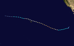
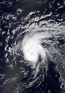
On July 24, visible imagery revealed Douglas' eye had become increasingly cloud filled while the storm's overall satellite appearance degraded.[16] Douglas entered the Central Pacific Hurricane Center's area of responsibility by 21:00 UTC on July 24.[17] As Douglas drifted over cooler sea surface temperatures, more weakening ensued as the system continued northwest.[18] Douglas eventually fell below major hurricane status late on July 24, and weakened to a Category 1 hurricane about 12 hours later.[19][20] At this time, Douglas was located roughly 325 miles east of Hilo, Hawaii.[21] Douglas continued a slow approach to the Hawaiian islands while retaining its intensity,[22] before weakening further as it passed north of Big Island.[23][24] Nonetheless the storm remained in quite healthy condition despite being among the cold sea surface temperatures and wind shear near Hawaii.[23] Douglas passed north of Maui at 1:00 UTC July 27, Oahu at 7:00 UTC, and Kauai at 22:00 UTC.[25][26][27] Douglas' close pass just 30 mi (48 km) north of Oahu broke the previous record set by Hurricane Dot for closest passing tropical cyclone to the island, whereas Dot passed about 60 mi (97 km) southwest of Oahu.[28] After moving away from Kauai, Douglas briefly re-intensified as confirmed from reconnaissance.[29] However, strengthening was very short-lived as wind shear quickly displaced deep convection from the storm's circulation.[30] Douglas weakened to a tropical storm shortly after,[31] and eventually became post-tropical by July 29.[32] Douglas' post-tropical low entered the Western Pacific basin later on July 30.[33]
Preparations and impact
In preparation for the arrival of Douglas in Hawaii, hurricane watches were raised for Big Island and Maui on July 24. A day prior the Governor of Hawaii, David Ige, issued a pre-landfall emergency proclamation as the state prepared for possible impacts from Hurricane Douglas. The proclamation authorized the expenditure of state funds for the quick and efficient relief of disaster-related damage, losses and suffering that may result from the storm. This proclamation ended on July 31.[34] By July 25, hurricane warnings were put in effect for Oahu and Kauai, while tropical storm warnings were issued for Big Island and Maui as Douglas' track forecast became more definitive.[35] Emergency sirens were blared across Oahu and Maui on July 26 as Douglas approached closer to the islands.[36] United States President Donald Trump issued an emergency declaration for the entire state in preparation of the hurricane.[36] In Oahu, 13 emergency shelters were opened across the island for those in need.[37]
Despite Douglas' close pass to the Hawaiian Islands, much of the islands were spared from the worst of the hurricane as only the weak southern eyewall of Douglas brushed the islands.[38] Overall damage was relatively minor, however storm surge and rainfall caused moderate flooding in Kauai and Oahu.[38] Winds never reached above hurricane-force, although a 69 mph wind gust occurred on Maui.[39] Rainfall totals also reached up to 6 inches in Maui and Oahu.[39] Maui Mayor Mike Victorino stated "You can pretty much see clear skies. We're so very thankful. I'm thankful that it passed us with very little damage and very little incidents."[40]
See also
- Other tropical cyclones named Douglas
- 2020 Pacific hurricane season
- List of Hawaii hurricanes
- List of Category 4 Pacific hurricanes
- Hurricane Gil (1983) – took a similar path and passed just north of Hawaii as a tropical storm
- Hurricane Olivia (2018) – a similar storm that made landfall in Maui as a minimal tropical storm
References
- "NHC Graphical Outlook Archive". nhc.noaa.gov. Retrieved July 29, 2020.
- "NHC Graphical Outlook Archive". nhc.noaa.gov. Retrieved July 29, 2020.
- "Tropical Depression EIGHT-E Forecast Discussion Number 1". nhc.noaa.gov. Retrieved July 29, 2020.
- "Tropical Depression EIGHT-E". nhc.noaa.gov. Retrieved July 29, 2020.
- "Tropical Storm DOUGLAS Forecast Discussion Number 3". nhc.noaa.gov. Retrieved July 29, 2020.
- "Tropical Storm DOUGLAS". nhc.noaa.gov. Retrieved July 29, 2020.
- "Tropical Storm DOUGLAS Forecast Discussion Number 4". nhc.noaa.gov. Retrieved July 29, 2020.
- "Tropical Storm DOUGLAS Forecast Discussion Number 5". nhc.noaa.gov. Retrieved July 29, 2020.
- "Tropical Storm DOUGLAS Forecast Discussion Number 6". nhc.noaa.gov. Retrieved July 29, 2020.
- "Tropical Storm DOUGLAS Forecast Discussion Number 7". nhc.noaa.gov. Retrieved July 29, 2020.
- "Hurricane DOUGLAS Forecast Discussion Number 9". nhc.noaa.gov. Retrieved July 29, 2020.
- "Hurricane DOUGLAS". nhc.noaa.gov. Retrieved July 29, 2020.
- "Hurricane DOUGLAS Forecast Discussion Number 12". nhc.noaa.gov. Retrieved July 29, 2020.
- "Hurricane DOUGLAS Forecast Discussion Number 13". nhc.noaa.gov. Retrieved July 29, 2020.
- "Hurricane DOUGLAS Forecast Discussion Number 15". nhc.noaa.gov. Retrieved July 29, 2020.
- "Hurricane DOUGLAS". nhc.noaa.gov. Retrieved July 29, 2020.
- "Hurricane DOUGLAS". nhc.noaa.gov. Retrieved August 1, 2020.
- "Hurricane DOUGLAS Forecast Discussion Number 18". nhc.noaa.gov. Retrieved July 29, 2020.
- "Hurricane DOUGLAS Forecast Discussion Number 20". nhc.noaa.gov. Retrieved July 31, 2020.
- "Hurricane DOUGLAS Forecast Discussion Number 22". nhc.noaa.gov. Retrieved July 31, 2020.
- "Hurricane DOUGLAS Public Advisory Number 22". nhc.noaa.gov. Retrieved July 31, 2020.
- "Hurricane DOUGLAS Forecast Discussion Number 24". nhc.noaa.gov. Retrieved July 31, 2020.
- "Hurricane DOUGLAS Forecast Discussion Number 26". nhc.noaa.gov. Retrieved July 31, 2020.
- "Hurricane DOUGLAS Public Advisory Number 25A". nhc.noaa.gov. Retrieved July 31, 2020.
- "Hurricane DOUGLAS". nhc.noaa.gov. Retrieved July 31, 2020.
- "Hurricane DOUGLAS". nhc.noaa.gov. Retrieved July 31, 2020.
- "Hurricane DOUGLAS". nhc.noaa.gov. Retrieved July 31, 2020.
- Service, NOAA's National Weather. "NWSChat - NOAA's National Weather Service". nwschat.weather.gov. Retrieved July 31, 2020.
- "Hurricane DOUGLAS Forecast Discussion Number 29". nhc.noaa.gov. Retrieved July 31, 2020.
- "Hurricane DOUGLAS Forecast Discussion Number 30". nhc.noaa.gov. Retrieved July 31, 2020.
- "Tropical Storm DOUGLAS". nhc.noaa.gov. Retrieved July 31, 2020.
- "Post-Tropical Cyclone DOUGLAS". nhc.noaa.gov. Retrieved July 31, 2020.
- "NASA finds Post-Tropical Low Douglas crossing a line". phys.org. Retrieved August 1, 2020.
- Ige, David (July 23, 2020). "Anticipation of Hurricane Douglas". governor.hawaii.gov. Retrieved July 29, 2020.
- "Hurricane DOUGLAS". nhc.noaa.gov. Retrieved August 1, 2020.
- News, A. B. C. "Hurricane Douglas swirls 'uncomfortably close' to Hawaii". ABC News. Retrieved August 1, 2020.
- "Hawaii Opens Shelters as Hurricane Douglas Approaches the Islands". The Weather Channel. Retrieved August 1, 2020.
- "Hurricane Douglas Blows by Hawaii, Leaving Little Damage Behind". The Weather Channel. Retrieved August 1, 2020.
- "Hawaiʻi Island Recorded Highest Wind From Hurricane Douglas". bigislandvideonews.com. Retrieved August 1, 2020.
- Staff, H. N. N. "'Very thankful': Maui mayor reports no major damage from Douglas". Hawaii News Now. Retrieved August 1, 2020.
External links
| Wikimedia Commons has media related to Hurricane Douglas (2020). |