Huntington (CDP), New York
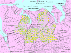
Huntington is a hamlet located in the Town of Huntington in Suffolk County, New York, United States. The Census Bureau has also defined a census-designated place (CDP) with the same name that corresponds to the most densely populated area, however local understanding of the hamlet may differ somewhat from the census definition. The aggregate demographic and geographic data for the hamlet is also included in the data for the Town of Huntington. The population was 18,406 at the 2010 census. The central business district, called Huntington Village locally, is old and well developed, but it is not incorporated and does not have a village form of government. The hamlet of Huntington is located 37 miles (59 km) northeast of Midtown Manhattan.
Huntington, New York | |
|---|---|
Hamlet and census-designated place | |
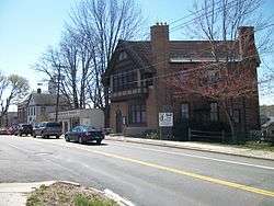
 The historic former Huntington Sewing & Trade School, now the headquarters of the Huntington Historical Society. | |
 U.S. Census Map | |
 Location within the state of New York | |
| Coordinates: 40°52′40″N 73°24′49″W | |
| Country | United States |
| State | New York |
| County | Suffolk |
| Area | |
| • Total | 7.73 sq mi (20.0 km2) |
| • Land | 7.59 sq mi (19.7 km2) |
| • Water | 0.14 sq mi (0.4 km2) |
| Elevation | 75 ft (23 m) |
| Population (2010) | |
| • Total | 21,457 |
| • Estimate (2016)[2] | 23,236 |
| • Density | 2,158.98/sq mi (833.59/km2) |
| Time zone | UTC-5 (EST) |
| • Summer (DST) | UTC-4 (EDT) |
| ZIP code | 11743 |
| Area code(s) | 631 |
| FIPS code | 36-36233 |
| GNIS feature ID | 0953488 |
Geography
Huntington is located at 40°52′40″N 73°24′49″W (40.877798, -73.413687).[3]
According to the United States Census Bureau, the CDP has a total area of 7.7 square miles (19.9 km²), of which, 7.5 square miles (19.5 km²) of it is land and 0.1 square miles (0.4 km²) of it (1.82%) is water.
Demographics
| Historical population | |||
|---|---|---|---|
| Census | Pop. | %± | |
| Est. 2016 | 203,236 | [2] | |
| U.S. Decennial Census[4] | |||
At the 2000 census there were 18,403 people, 7,052 households, and 4,992 families in the CDP. The population density was 2,442.5 per square mile (943.6/km²). There were 7,273 housing units at an average density of 965.3/sq mi (372.9/km²). The racial makeup of the CDP was 93.71% White, 2.09% Black or African American, 0.11% Native American, 1.80% Asian, 0.01% Pacific Islander, 1.14% from other races, and 1.13% from two or more races. Hispanic or Latino of any race were 3.58%.[5]
Of the 7,052 households 31.7% had children under the age of 18 living with them, 60.7% were married couples living together, 7.2% had a female householder with no husband present, and 29.2% were non-families. 23.4% of households were one person and 8.8% were one person aged 65 or older. The average household size was 2.59 and the average family size was 3.08.
The age distribution was 23.1% under the age of 18, 4.9% from 18 to 24, 31.6% from 25 to 44, 26.2% from 45 to 64, and 14.1% 65 or older. The median age was 40 years. For every 100 females, there were 94.6 males. For every 100 females age 18 and over, there were 91.8 males.
The median household income was $82,934 and the median family income was $100,494. Males had a median income of $71,164 versus $45,027 for females. The per capita income for the CDP was $42,960. About 1.9% of families and 3.8% of the population were below the poverty line, including 3.2% of those under age 18 and 6.3% of those age 65 or over.
Transportation
The village area is very walkable, and is served by several bus routes. The S1 operates along Route 110 from Halesite to Amityville, while the H10, H20, and H30 (operated by Huntington Area Rapid Transit serve different portions of the village.[6] The S1, H10, and H20 all provide a direct connection to the LIRR hub at Huntington (the station itself is actually located in the hamlet of Huntington Station)
References
- "2016 U.S. Gazetteer Files". United States Census Bureau. Retrieved Jul 5, 2017.
- "Population and Housing Unit Estimates". Retrieved June 9, 2017.
- "US Gazetteer files: 2010, 2000, and 1990". United States Census Bureau. 2011-02-12. Retrieved 2011-04-23.
- "Census of Population and Housing". Census.gov. Retrieved June 4, 2016.
- "U.S. Census website". United States Census Bureau. Retrieved 2008-01-31.
- "Archived copy" (PDF). Archived from the original (PDF) on 2016-12-29. Retrieved 2013-10-14.CS1 maint: archived copy as title (link)
External links
| Wikimedia Commons has media related to Huntington, New York. |

- Huntington Historical Society