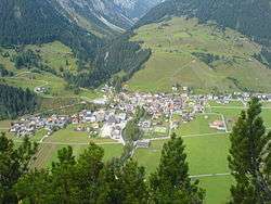
Holzgau
Holzgau is a municipality in the district of Reutte in the Austrian state of Tyrol.
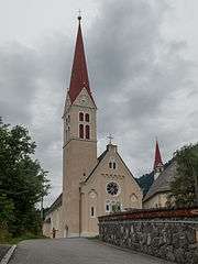
Church: katholische Pfarrkirche Unsere Liebe Frau Mariae Himmelfahrt
Holzgau | |
|---|---|
 | |
 Coat of arms | |
 Holzgau Location within Austria | |
| Coordinates: 47°15′50″N 10°20′50″E | |
| Country | Austria |
| State | Tyrol |
| District | Reutte |
| Government | |
| • Mayor | Günter Blaas |
| Area | |
| • Total | 36.05 km2 (13.92 sq mi) |
| Elevation | 1,103 m (3,619 ft) |
| Population (2018-01-01)[2] | |
| • Total | 412 |
| • Density | 11/km2 (30/sq mi) |
| Time zone | UTC+1 (CET) |
| • Summer (DST) | UTC+2 (CEST) |
| Postal code | 6654 |
| Area code | 05633 |
| Vehicle registration | RE |
| Website | www.holzgau. tirol.gv.at |
History
The main village of the municipality is situated in the valley Lechtal on the fan of the Höhenbach. The village was first mentioned in 1315 as Holzge, later as Holzgaw. In 1401 it became an autonomous parish.
The village is mainly known for its houses with painted façades. Some of them have been thoroughly renovated during the past decades. The regional museum gives an impression of the life of former generations in the upper part of the valley Lechtal. The Simms waterfall was created in the 19th century by the British industrialist Frederick Richard Simms.
Climate
| Climate data for Holzgau (1971–2000) | |||||||||||||
|---|---|---|---|---|---|---|---|---|---|---|---|---|---|
| Month | Jan | Feb | Mar | Apr | May | Jun | Jul | Aug | Sep | Oct | Nov | Dec | Year |
| Record high °C (°F) | 14.1 (57.4) |
16.4 (61.5) |
21.2 (70.2) |
23.5 (74.3) |
28.4 (83.1) |
30.8 (87.4) |
33.0 (91.4) |
33.0 (91.4) |
30.0 (86.0) |
24.3 (75.7) |
19.4 (66.9) |
14.8 (58.6) |
33.0 (91.4) |
| Average high °C (°F) | 0.4 (32.7) |
3.8 (38.8) |
7.6 (45.7) |
10.7 (51.3) |
16.3 (61.3) |
18.7 (65.7) |
21.3 (70.3) |
21.2 (70.2) |
18.1 (64.6) |
13.2 (55.8) |
4.8 (40.6) |
0.7 (33.3) |
11.4 (52.5) |
| Daily mean °C (°F) | −3.9 (25.0) |
−2.5 (27.5) |
0.9 (33.6) |
4.2 (39.6) |
9.5 (49.1) |
12.3 (54.1) |
14.6 (58.3) |
14.2 (57.6) |
10.8 (51.4) |
6.2 (43.2) |
0.0 (32.0) |
−3.0 (26.6) |
5.3 (41.5) |
| Average low °C (°F) | −7.3 (18.9) |
−6.7 (19.9) |
−3.5 (25.7) |
−0.5 (31.1) |
3.7 (38.7) |
6.6 (43.9) |
8.9 (48.0) |
8.9 (48.0) |
5.9 (42.6) |
1.9 (35.4) |
−3.3 (26.1) |
−6.1 (21.0) |
0.7 (33.3) |
| Record low °C (°F) | −27.5 (−17.5) |
−23.5 (−10.3) |
−24.8 (−12.6) |
−11.0 (12.2) |
−7.4 (18.7) |
−1.5 (29.3) |
0.2 (32.4) |
0.0 (32.0) |
−4.1 (24.6) |
−10.4 (13.3) |
−19.4 (−2.9) |
−22.4 (−8.3) |
−27.5 (−17.5) |
| Average precipitation mm (inches) | 91.4 (3.60) |
84.5 (3.33) |
91.1 (3.59) |
76.7 (3.02) |
100.9 (3.97) |
151.7 (5.97) |
177.7 (7.00) |
165.4 (6.51) |
110.1 (4.33) |
82.0 (3.23) |
102.5 (4.04) |
100.8 (3.97) |
1,334.8 (52.55) |
| Average snowfall cm (inches) | 95.7 (37.7) |
96.6 (38.0) |
81.6 (32.1) |
30.0 (11.8) |
5.6 (2.2) |
0.1 (0.0) |
0.0 (0.0) |
0.0 (0.0) |
0.1 (0.0) |
5.2 (2.0) |
44.2 (17.4) |
77.2 (30.4) |
436.3 (171.8) |
| Average precipitation days (≥ 1.0 mm) | 10.5 | 9.0 | 11.6 | 11.5 | 13.5 | 16.4 | 15.7 | 15.3 | 11.8 | 9.5 | 11.0 | 11.0 | 146.8 |
| Average relative humidity (%) (at 14:00) | 74.5 | 61.1 | 52.9 | 51.8 | 51.8 | 55.2 | 53.7 | 54.5 | 54.4 | 57.5 | 71.4 | 78.6 | 59.8 |
| Source: Central Institute for Meteorology and Geodynamics[3] | |||||||||||||
Personalities
Josef Strobl (born 1974 in Holzgau) - former Austrian skiracer
gollark: Of course, it's on my laptop.
gollark: I think I could detect winning boards slightly more efficiently, but that's only a linear speedup.
gollark: Yes.
gollark: Here is an example.
gollark: Lines can be highly diagonal. I'll retrieve the visualization.
References
- "Dauersiedlungsraum der Gemeinden Politischen Bezirke und Bundesländer - Gebietsstand 1.1.2018". Statistics Austria. Retrieved 10 March 2019.
- "Einwohnerzahl 1.1.2018 nach Gemeinden mit Status, Gebietsstand 1.1.2018". Statistics Austria. Retrieved 9 March 2019.
- "Klimadaten von Österreich 1971–2000 – Tirol-Holzgau" (in German). Central Institute for Meteorology and Geodynamics. Archived from the original on 12 October 2019. Retrieved 20 October 2019.
| Wikimedia Commons has media related to Holzgau. |
| Authority control |
|
|---|
This article is issued from Wikipedia. The text is licensed under Creative Commons - Attribution - Sharealike. Additional terms may apply for the media files.