Hirao
Hirao (平生町, Hirao-chō) is a town located in Kumage District, Yamaguchi Prefecture, Japan.
Hirao 平生町 | |
|---|---|
Town | |
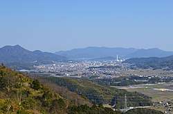 Hirao town hall viewed from Mt Iwaki | |
 Flag | |
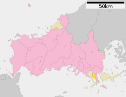 Location of Hirao in Yamaguchi Prefecture | |
 Hirao Location in Japan | |
| Coordinates: 33°56′N 132°04′E | |
| Country | Japan |
| Region | Chūgoku San'yō |
| Prefecture | Yamaguchi Prefecture |
| District | Kumage |
| Government | |
| • Mayor | Kunihiro Asamoto |
| Area | |
| • Total | 34.40 km2 (13.28 sq mi) |
| Population (October 1, 2016) | |
| • Total | 12,643 |
| • Density | 370/km2 (950/sq mi) |
| Time zone | UTC+9 (JST) |
| Website | www |
As of 2016, the town has an estimated population of 12,643 and a density of 370 inhabitants per square kilometre (958.30/sq mi). The total area is 34.40 km2 (13.28 sq mi).
Geography
Neighbouring municipalities
Transportation
Hirao did not have any train stations, with the Yanai station being the closest from the town and takes about a ten-minute travel from the town. Japan National Route 188 passes through Hirao.
gollark: Maybe I should attain a coral-like domain like `60.nu`.
gollark: Well, I could use one of my cloud™ servers, but spam filters.
gollark: Unless I can.
gollark: I can't actually do email.
gollark: Wait for registration? Oops.
External links

- Hirao official website (in Japanese)
Yamaguchi (capital) | ||
| Core city | ||
| Cities | ||
| Districts | ||
| Authority control |
|
|---|
This article is issued from Wikipedia. The text is licensed under Creative Commons - Attribution - Sharealike. Additional terms may apply for the media files.