Hinton, Oklahoma
Hinton is a town in Caddo County, Oklahoma, United States. The population was 3,196 as of the 2010 census,[5] up from 2,175 at the 2000 census. It is approximately 50 miles (80 km) west of Oklahoma City.
Hinton, Oklahoma | |
|---|---|
| Motto(s): "Always Growing Always Prospering" | |
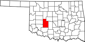
Location of Hinton, Oklahoma | |
| Coordinates: 35°28′44″N 98°21′13″W | |
| Country | United States |
| State | Oklahoma |
| County | Caddo |
| Area | |
| • Total | 3.19 sq mi (8.25 km2) |
| • Land | 3.14 sq mi (8.12 km2) |
| • Water | 0.05 sq mi (0.13 km2) |
| Elevation | 1,680 ft (512 m) |
| Population (2010) | |
| • Total | 3,196 |
| • Estimate (2019)[2] | 3,219 |
| • Density | 1,026.14/sq mi (396.22/km2) |
| Time zone | UTC-6 (Central (CST)) |
| • Summer (DST) | UTC-5 (CDT) |
| ZIP code | 73047 |
| Area code(s) | 405 |
| FIPS code | 40-34750[3] |
| GNIS feature ID | 1093794[4] |
| Website | hintonok |
Geography
Hinton is located in northeastern Caddo County at 35°28′44″N 98°21′13″W (35.479004, -98.353748),[6] at an elevation 1,676 feet (511 m). The town limits extend north from the settled part of town 4 miles (6 km) along U.S. Route 281 to Interstate 40 at Exit 101. From there it is 49 miles (79 km) east to the center of Oklahoma City.
According to the United States Census Bureau, the town of Hinton has a total area of 3.1 square miles (8.1 km2), all of it land.[5]
Demographics
| Historical population | |||
|---|---|---|---|
| Census | Pop. | %± | |
| 1910 | 686 | — | |
| 1920 | 744 | 8.5% | |
| 1930 | 1,009 | 35.6% | |
| 1940 | 842 | −16.6% | |
| 1950 | 1,025 | 21.7% | |
| 1960 | 907 | −11.5% | |
| 1970 | 889 | −2.0% | |
| 1980 | 1,432 | 61.1% | |
| 1990 | 1,233 | −13.9% | |
| 2000 | 2,175 | 76.4% | |
| 2010 | 3,196 | 46.9% | |
| Est. 2019 | 3,219 | [2] | 0.7% |
| U.S. Decennial Census[7] | |||
As of the census[3] of 2000, there were 2,175 people, 575 households, and 412 families residing in the town. The population density was 691.5 people per square mile (266.6/km2). There were 667 housing units at an average density of 211.7 per square mile (81.6/km2). The racial makeup of the town was 73.66% White, 13.15% African American, 4.83% Native American, 0.14% Asian, 4.37% from other races, and 3.86% from two or more races. Hispanic or Latino of any race were 8.46% of the population.
There were 575 households, out of which 36.2% had children under the age of 18 living with them, 56.5% were married couples living together, 12.0% had a female householder with no husband present, and 28.3% were non-families. 26.3% of all households were made up of individuals, and 15.1% had someone living alone who was 65 years of age or older. The average household size was 2.50 and the average family size was 3.01.
In the town, the population was spread out, with 18.9% under the age of 18, 11.6% from 18 to 24, 38.6% from 25 to 44, 18.8% from 45 to 64, and 12.1% who were 65 years of age or older. The median age was 35 years. For every 100 females, there were 175.0 males. For every 100 females age 18 and over, there were 197.0 males.
The median income for a household in the town was $29,028, and the median income for a family was $33,239. Males had a median income of $25,455 versus $20,556 for females. The per capita income for the town was $12,105. About 12.2% of families and 16.2% of the population were below the poverty line, including 19.7% of those under age 18 and 16.8% of those age 65 or over.
Tourism
Red Rock Canyon Adventure Park is located 1 mile (1.6 km) south of downtown Hinton. The park is a favorite of rappellers due to the canyon's cliff formations. It also boasts beautiful trees, especially in the fall when the color of the leaves begin to turn. Camping and day picnicking are allowed, and there is a 1-acre (4,000 m2) lake for fishing. Hiking around the canyon is allowed within park limits. The park has a pool that offers two water slides into the 8-foot-deep (2.4 m) water as well as water 3 feet (0.91 m) deep for younger swimmers. The pool is overseen by certified lifeguards, and at least one lifeguard is on duty at all times.
Corrections
Hinton is also the site of the Great Plains Correctional Institution, opened in 1991 as the state's first private prison, and holding non-U.S. citizen federal inmates as of 2016.
Casino
Sugar Creek Casino is located just off I-40 in Hinton. The casino is an enterprise of the Wichita and affiliated tribes. Casino Oklahoma is located just off I-40 on the east side of highway 281 and Hinton BLVD, and is an enterprise of the Delaware Nation.
References
- "2019 U.S. Gazetteer Files". United States Census Bureau. Retrieved July 28, 2020.
- "Population and Housing Unit Estimates". United States Census Bureau. May 24, 2020. Retrieved May 27, 2020.
- "U.S. Census website". United States Census Bureau. Retrieved 2008-01-31.
- "US Board on Geographic Names". United States Geological Survey. 2007-10-25. Retrieved 2008-01-31.
- "Geographic Identifiers: 2010 Demographic Profile Data (G001): Hinton town, Oklahoma". U.S. Census Bureau, American Factfinder. Archived from the original on February 9, 2015. Retrieved February 6, 2015.
- "US Gazetteer files: 2010, 2000, and 1990". United States Census Bureau. 2011-02-12. Retrieved 2011-04-23.
- "Census of Population and Housing". Census.gov. Retrieved June 4, 2015.
