Hemispheres of Earth
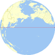
In geography and cartography, the hemispheres of Earth refer to any division of the globe into two hemispheres (from Ancient Greek ἡμισφαίριον hēmisphairion, meaning "half of a sphere").

The most common such divisions are by latitudinal or longitudinal markers[1]:
- North–South
- Northern Hemisphere, the half that lies north of the Equator
- Southern Hemisphere, the half that lies south of the Equator
- East–West
- Eastern Hemisphere, the half that lies east of the prime meridian and west of the 180th meridian
- Western Hemisphere, the half that lies west of the prime meridian and east of the 180th meridian
The East–West division can also be seen in a cultural sense, as a division into two cultural hemispheres.
However, other schemes have sought to divide the planet in a way that maximizes the preponderance of one geographic feature or another in each division:
- Land–Water [2]
- Land Hemisphere, the hemisphere on Earth containing the largest possible area of land
- Water Hemisphere, the hemisphere on Earth containing the largest area of water

The Land Hemisphere

The Water Hemisphere

The Land Hemisphere is at the top, and the Water Hemisphere is at the bottom.

The Land Hemisphere is at the top and the Water Hemisphere is at the bottom
Earth may also be split into hemispheres of day and night by the terrestrial terminator.
See also
References
- "Hemisphere". 2011-03-22.
- Boggs, S. W. (1945). "This Hemisphere". Journal of Geography. 44 (9): 345–355. doi:10.1080/00221344508986498.
External links
![]()
This article is issued from Wikipedia. The text is licensed under Creative Commons - Attribution - Sharealike. Additional terms may apply for the media files.