Heiðin há
Heiðin há is a shield volcano up on Hellisheiði at about 35 km to the south of Reykjavík in Iceland. The mountain has a height of 626 m.[1]
| Heiðin há | |
|---|---|
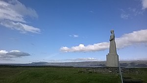 Heiðin há, seen from the statue Landsýn near Strandarkirkja in Selvogur]]l | |
| Highest point | |
| Elevation | 626 m (2,054 ft) (Björn Hróarsson: Hellahandbókin. Leiðsögn um 77 íslenska hraunhella. Reykjavík 2008, p. 103) |
| Coordinates | 63°56′00″N 21°39′00″W |
| Naming | |
| English translation | High Moorland |
| Language of name | Icelandic |
| Geography | |
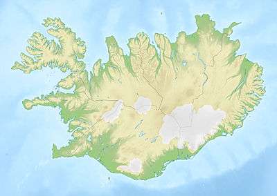 Heiðin há Iceland | |
| Geology | |
| Age of rock | Holocene |
| Mountain type | Shield volcano |
| Last eruption | Holocene |
Shield volcano
The volcano dates from the Mid-Holocene, is - following B. Hróarsson - about 6 000 years old, slightly younger than the Selvogsheiði, another shield volcano on Reykjanes peninsula,[1], whereas Sinton defines its age as “finiglacial”, which would mean from the beginning of Holocene.[2]
It covers about 160km2 and its volume is about 10km3[1]. The volcano is part of the Brennisteinsfjöll volcanic system.
The top crater is located south of Bláfjöll. It has a diameter of ca. 400m, but is mostly filled by lava up to the rim.[1]
The lava flows from Heiðin há went in all directions on Hellisheiði: They covered the highland up to the Bláfjöll and up to the tuya Geitafell in eastern direction, and enclosed the older shield volcano Selvogsheiði as well as the mountain Urðarfell.[1]
Lava tubes of Heiðin há
Some lava tubes were discovered in the lava of Heiðin há. Speleologists esp. discribe Kuluhattshellar("Bowler Hat Caves") and Fosshellir.[3]The first lava tube is rather eroded, but shows anyway some fine lava stalactites, whereas the second one prides a lava fall as the name says (= "Water/Lava fall cave").[3]
Slopes of Heiðin há
The slopes of the shield volcano are cut by some small canyons, esp. Strandagjá, Hrossagjá, Réttargjá and Götugjá.[1]
Selvogsgata – an old trail
.jpg)
The trail leads from the farms near the Selvogur bay (Árnessýsla) on the south coast of Reykjanes up to Hafnarfjörður in the vicinity of Reykjavík. In such, it traverses the Reykjanes peninsula from south to north at a length of about 25 km. [4][5]
Importance of the trail
This old trail, Selvogsgata, traverses a big part of the slopes of the shield volcano Heiðin há.
It was used by people on foot or on horseback who wanted to reach the market place in Hafnarfjörður. As such the trail was used til around 1930 with pack horses, and on foot even til around 1960. It was not before around 1939 that the farms in the area of Selvogur had a road installed, and one, they could use the whole year round, even not before 1948. Last were sheep brought over Selvogsgata to Hafnarfjörður in the end forties at the beginning of winter and it took the farmers about 14 hours to get with their herd from Selvogur to the market town, with snowfall parts of the way.[4]
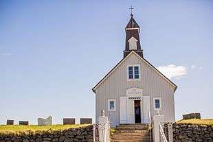
Beginning of the trail: Strandarkirkja
The trail starts out not far from Strandarkirkja, a church on the southern coast of Reykjanes west of Þorlákshöfn. [4]
The church Strandarkirkja is from timber, was constructed around the turn of the 19th century and renovated in the 1960s. It is said that seamen in distress let built the church after their rescue in fulfilling a vow. Though this is a Lutheran church, pilgrimages to her are organized still today and votiv offerings can be seen in the church.[6]
The trail over Hellisheidi and Heiðin há
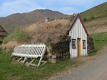
The trail is not marked, but well to discern except in winter time. After about 1 km up the hill slope, one is coming in the area of Heiðin há, because here, the trail lies over Katlahraun lava field, one of the lava flows produced by the shield volcano. This lava reaches into the valley Hlíðardal and from there up on Hvalskarð. Some moorland is here to be found where in former times the people from Selvogur took the turf for fire making and the construction of their Icelandic turf houses.[4]
The small pass Hvalskarð is also well feasible on horseback. From some heights in the vicinity, there is a nice view of Iceland’s south coast. A fólktale says, a troll woman from up here had stolen a whale carcass from the beach down in Selvogur. But the farmer who was the proprietor of the beach and therefore of the whale, followed her and got her at Hvalskarð (thence the name: Whale pass). [4]
After the pass, the trail continues to Kóngsfell, from there to Grindarskörð, and then down in direction of the lava fields between the Brennisteinsfjöll and Hafnarfjörður, where it is possible to chose between some other trails. [4]
Today the trail crosses Route 417 at the foot of Grindarskörð.
Hiking trail
This trail is today a popular hiking trail.[1]It is possible to follow it just from/up to a parking lot at Route 417 near Grindarskörð[7].
External links
References
- Björn Hróarsson: Hellahandbókin. Leiðsögn um 77 íslenska hraunhella. Reykjavík 2008, p. 103
- J. Sinton, etal.: Postglacial eruptive history of the Western Volcanic Zone, Iceland. In: Geochemistry, geophysics, geosystems. Volume 6, Number 12. 31 December 2005 Q12009, doi:10.1029/2005GC001021
- Björn Hróarsson: Hellahandbókin. Leiðsögn um 77 íslenska hraunhella. Reykjavík 2008, p. 103-105
- Þór Vigfússon: Í Árnesþingi vestanverðu. Ferðafélag Íslands Árbók 2003. Reykjavík 2003, p. 62-69 For a map, see there p. 62
- See also: Selvogsgata forna þjóðleiðin. Morgunblaðið 13. september 1995 https://www.mbl.is/greinasafn/grein/221850/ Retrieved 1 August 2010.
- Íslandshandbókin. Náttúra, saga of sérkenni. Reykjavík 1989, p. 830-31
- Wikiloc.com See map here.