Hedleyhope Fell
Hedleyhope Fell is a nature reserve to the north-east of Tow Law, County Durham, England. The reserve is managed by Durham Wildlife Trust and consists of some 200 acres of mainly mid-altitude heathland.[1] It occupies the steep slope on the right bank of Hedleyhope Burn, between the stream and the B6301 Tow Law–Cornsay Colliery road.
| Hedleyhope Fell | |
|---|---|
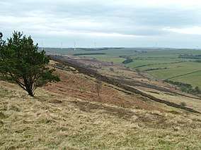 A view of Hedleyhope Fell Nature Reserve, County Durham | |
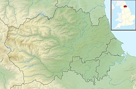 Location of Hedleyhope Fell NR, County Durham | |
| Location | County Durham, England |
| Coordinates | 54°46′56″N 1°46′59″W |
| Area | 200 ha (490 acres) |
| Established | 2006 |
| Named for | Old English hedley or headlam (heathery place) and hope (valley) |
| Governing body | Durham Wildlife Trust |
| Website | Reserve description |
The reserve is common land and forms part of Hedleyhope Fell and Cornsay Common.
References
- "Hedleyhope Fell". Durham Wildlife Trust. Archived from the original on 17 July 2012. Retrieved 13 March 2011.
This article is issued from Wikipedia. The text is licensed under Creative Commons - Attribution - Sharealike. Additional terms may apply for the media files.