Harrison Township, Franklin County, Kansas
Harrison Township is a township in Franklin County, Kansas, USA. As of the 2000 census, its population was 445.
Harrison Township | |
|---|---|
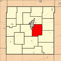 Location in Franklin County | |
| Coordinates: 38°34′10″N 095°13′16″W | |
| Country | United States |
| State | Kansas |
| County | Franklin |
| Area | |
| • Total | 27.7 sq mi (71.74 km2) |
| • Land | 27.46 sq mi (71.13 km2) |
| • Water | 0.23 sq mi (0.6 km2) 0.84% |
| Elevation | 984 ft (300 m) |
| Population (2000) | |
| • Total | 445 |
| • Density | 16.2/sq mi (6.3/km2) |
| GNIS feature ID | 0479679 |
Geography
Harrison Township covers an area of 27.7 square miles (72 km2) and contains no incorporated settlements. According to the USGS, it contains two cemeteries: Fouts and Roselawn.
The streams of Rock Creek and Sac Branch run through this township.
Transportation
Harrison Township contains one airport or landing strip, Ottawa Municipal Airport.
gollark: Well, I would actually.
gollark: <@151391317740486657> Monitors are superior to pathetic „signs„.
gollark: Okay, just tell me tomorrow, the virtual keyboard is annoyinger than I thought.
gollark: Ah.
gollark: Yep. Adding.
External links
Municipalities and communities of Franklin County, Kansas, United States | ||
|---|---|---|
| Cities | 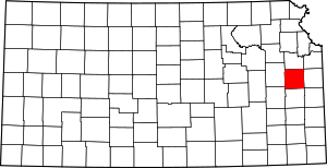 Map of Kansas highlighting Franklin County | |
| Unincorporated communities | ||
| Ghost towns | ||
| Townships | ||
This article is issued from Wikipedia. The text is licensed under Creative Commons - Attribution - Sharealike. Additional terms may apply for the media files.