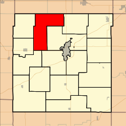
Centropolis Township, Franklin County, Kansas
Centropolis Township is a township in Franklin County, Kansas, USA. As of the 2000 census, its population was 997.
Centropolis Township | |
|---|---|
 Location in Franklin County | |
| Coordinates: 38°40′55″N 095°22′16″W | |
| Country | United States |
| State | Kansas |
| County | Franklin |
| Area | |
| • Total | 40.82 sq mi (105.72 km2) |
| • Land | 40.68 sq mi (105.36 km2) |
| • Water | 0.14 sq mi (0.36 km2) 0.34% |
| Elevation | 1,004 ft (306 m) |
| Population (2000) | |
| • Total | 997 |
| • Density | 24.5/sq mi (9.5/km2) |
| GNIS feature ID | 0479339 |
Geography
Centropolis Township covers an area of 40.82 square miles (105.7 km2) and contains no incorporated settlements. According to the USGS, it contains two cemeteries: Kaub and Pleasant Hill.
The streams of Cole Creek, Minneola Creek and West Fork Eightmile Creek run through this township.
gollark: The market's not random.
gollark: It's just that with NDs the chances are much higher and there's more interaction.
gollark: Yes, but you probably wouldn't.
gollark: It'd be nicer if they were allowed on the forums, and if there wasn't such a crazy and stupid attitude to reverse engineering.
gollark: Well, mostly.
External links
Municipalities and communities of Franklin County, Kansas, United States | ||
|---|---|---|
| Cities | 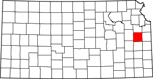 Map of Kansas highlighting Franklin County | |
| Unincorporated communities | ||
| Ghost towns | ||
| Townships | ||
This article is issued from Wikipedia. The text is licensed under Creative Commons - Attribution - Sharealike. Additional terms may apply for the media files.