Handy, Kansas
Handy was a small settlement in Bloom Township, Osborne County, Kansas, United States.
Handy, Kansas | |
|---|---|
| Coordinates: 39°22′45″N 98°32′45″W | |
| Country | United States |
| State | Kansas |
| County | Osborne |
| Elevation | 1,585 ft (483 m) |
| Time zone | UTC-6 (Central (CST)) |
| • Summer (DST) | UTC-5 (CDT) |
| GNIS feature ID | 481895[1] |


History
Handy was never a ghost town by any stretch of the imagination, but it was a rural post office in a farmhouse - nothing more. Handy was organized as a post office in 1882. The post office was discontinued in 1889.[2]
gollark: I mean, they're an artist for it, who knows what crazy data collection Google has.
gollark: What thing isn't?
gollark: Quite high, since google spies on your preferred thingies.
gollark: I mean, if you want to sort them that way, that is.
gollark: If you must, just switch to "small sprite"/"big sprite".
References
- "US Board on Geographic Names". United States Geological Handy. 1984-07-01. Retrieved 2017-12-30.
- "Kansas Post Offices, 1828-1961". Kansas Historical Society. Retrieved 2017-12-30.
Municipalities and communities of Osborne County, Kansas, United States | ||
|---|---|---|
| Cities | 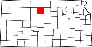 Map of Kansas highlighting Osborne County | |
| Unincorporated communities | ||
| Ghost towns | ||
| Townships |
| |
This article is issued from Wikipedia. The text is licensed under Creative Commons - Attribution - Sharealike. Additional terms may apply for the media files.