Halle, Bentheim
Halle is a village in the Joint Community (Samtgemeinde) of Uelsen, in the district of Grafschaft Bentheim in Lower Saxony.
Halle | |
|---|---|
Location of Halle within Grafschaft Bentheim district 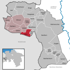  | |
 Halle 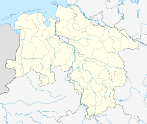 Halle | |
| Coordinates: 52°27′N 6°55′E | |
| Country | Germany |
| State | Lower Saxony |
| District | Grafschaft Bentheim |
| Municipal assoc. | Uelsen |
| Subdivisions | 3 Ortsteile |
| Government | |
| • Mayor | Gerrt Beckhuis |
| Area | |
| • Total | 21.15 km2 (8.17 sq mi) |
| Elevation | 28 m (92 ft) |
| Population (2018-12-31)[1] | |
| • Total | 666 |
| • Density | 31/km2 (82/sq mi) |
| Time zone | CET/CEST (UTC+1/+2) |
| Postal codes | 49843 |
| Dialling codes | 05941 |
| Vehicle registration | NOH |
| Website | www.uelsen.de/samtgem/fhalle.HTML |
The community, to which the centres of Hardingen (amalgamated in 1974) and Hesingen also belong, has 654 inhabitants (as of June 2005) and spans 21.15 km².
The community’s mayor is Geert Beckhuis.
The Poascheberg in Hesingen is, with an elevation of 89 m above sea level, the highest point in the lower part of the old County of Bentheim.
Unlike the people of the better known and bigger city of Halle in Saxony-Anhalt, who call themselves Hallenser in German, the inhabitants here call themselves simply Haller, following the usual German rule for formulating nouns denoting a particular place’s inhabitants.
Further centres are Belthoek, Bovenhoek, Dalenhoek, Erstenhoek and Kleihoek.