Getelo
Getelo is a community in the district of Grafschaft Bentheim in Lower Saxony.
Getelo | |
|---|---|
 Coat of arms | |
Location of Getelo within Grafschaft Bentheim district 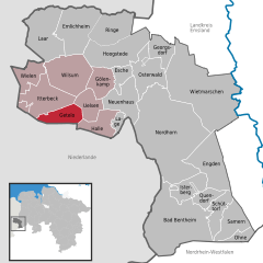  | |
 Getelo 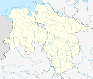 Getelo | |
| Coordinates: 52°28′00″N 06°50′59″E | |
| Country | Germany |
| State | Lower Saxony |
| District | Grafschaft Bentheim |
| Municipal assoc. | Uelsen |
| Subdivisions | 2 centres |
| Government | |
| • Mayor | Jan- Hindrik Schipper |
| Area | |
| • Total | 20.24 km2 (7.81 sq mi) |
| Elevation | 68 m (223 ft) |
| Population (2018-12-31)[1] | |
| • Total | 535 |
| • Density | 26/km2 (68/sq mi) |
| Time zone | CET/CEST (UTC+1/+2) |
| Postal codes | 49843 |
| Dialling codes | 0 59 42 |
| Vehicle registration | NOH |
| Website | www.uelsen.de/samtgem/fgetelo.HTML |
Geography
Location
Getelo lies west of Nordhorn on the border with the Netherlands. It belongs to the Joint Community (Samtgemeinde) of Uelsen, whose administrative seat is in the like-named community.
Constituent communities
The community’s two centres are Getelo and Getelomoor.
Politics
Mayor
The honorary mayor Jan-Hindrik Schipper was elected on 9 September 2001.
Culture and sightseeing
Buildings
Söven Pölle, barrows from the Bronze Age, are found in the community. The name gives the number as seven, although there were once as many as 26.
Economy and infrastructure
Transport
Various state highways and district roads join the community to Bundesstraße 403, about 10 km away.
gollark: Experience music™.
gollark: (it uses notes, and intervals)
gollark: It has an excellent user UI interface.
gollark: On Android I use RedReader.
gollark: It's surprisingly difficult to make correct-sounding beeping noises, so I didn't.
External links
Towns and municipalities in Grafschaft Bentheim (district) | ||
|---|---|---|
Coat of arms | ||
| Authority control |
|
|---|
This article is issued from Wikipedia. The text is licensed under Creative Commons - Attribution - Sharealike. Additional terms may apply for the media files.