Gruyères, Ardennes
Gruyères is a commune in the Ardennes department in northern France.
Gruyères | |
|---|---|
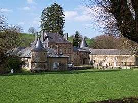 The chateau in Gruyères | |
 Coat of arms | |
Location of Gruyères 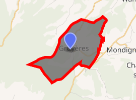
| |
 Gruyères  Gruyères | |
| Coordinates: 49°42′38″N 4°36′09″E | |
| Country | France |
| Region | Grand Est |
| Department | Ardennes |
| Arrondissement | Charleville-Mézières |
| Canton | Signy-l'Abbaye |
| Intercommunality | Crêtes Préardennaises |
| Government | |
| • Mayor (2008–2014) | Bernard Blaimont |
| Area 1 | 5.48 km2 (2.12 sq mi) |
| Population (2017-01-01)[1] | 99 |
| • Density | 18/km2 (47/sq mi) |
| Time zone | UTC+01:00 (CET) |
| • Summer (DST) | UTC+02:00 (CEST) |
| INSEE/Postal code | 08201 /08430 |
| Elevation | 211–306 m (692–1,004 ft) (avg. 220 m or 720 ft) |
| 1 French Land Register data, which excludes lakes, ponds, glaciers > 1 km2 (0.386 sq mi or 247 acres) and river estuaries. | |
Population
| Year | Pop. | ±% |
|---|---|---|
| 1962 | 28 | — |
| 1968 | 34 | +21.4% |
| 1975 | 44 | +29.4% |
| 1982 | 49 | +11.4% |
| 1990 | 52 | +6.1% |
| 1999 | 51 | −1.9% |
| 2008 | 65 | +27.5% |
gollark: Oh, wait, I already did it this time.
gollark: That would be fun for the next code guessing round.
gollark: What if you make a better macro system for C so that this works?
gollark: As planned.
gollark: https://lhartikk.github.io/jekyll/update/2017/07/12/chapter3.html
See also
References
- "Populations légales 2017". INSEE. Retrieved 6 January 2020.
| Wikimedia Commons has media related to Gruyères, Ardennes. |
| Authority control |
|
|---|
This article is issued from Wikipedia. The text is licensed under Creative Commons - Attribution - Sharealike. Additional terms may apply for the media files.