Greystoke, Cumbria
Greystoke is a village and civil parish on the edge of the Lake District National Park in Cumbria, England, about 4 miles (6.4 km) west of Penrith. The village centres on a green surrounded by stone houses and cottages.
| Greystoke | |
|---|---|
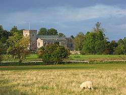 St Andrew's Church | |
 Greystoke Location within Cumbria | |
| Population | 654 (2011)[1] |
| OS grid reference | NY4430 |
| Civil parish |
|
| District |
|
| Shire county | |
| Region | |
| Country | England |
| Sovereign state | United Kingdom |
| Post town | PENRITH |
| Postcode district | CA11 |
| Dialling code | 017684 |
| Police | Cumbria |
| Fire | Cumbria |
| Ambulance | North West |
| UK Parliament |
|
Buildings
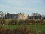
Buildings in the village include St Andrew's parish church, which dates from the 13th century; Greystoke Castle, built by Baron Greystock in the 16th century and which stands in a 3,000-acre (12 km2) park; the Boot & Shoe public house; and the Cyclists' Cafe.
To the east of the village are three folly farmsteads built about 1789 by Charles Howard, 11th Duke of Norfolk, of Greystoke Castle: Fort Putnam, Bunker's Hill and Spire House.
St Andrew's Church
St Andrew's is a major church building due to its size, which is considerable for such a small parish. It was refounded as a collegiate church in 1382, by William, 14th Baron Greystoke, for a master, seven chaplains and six chantry priests. However the present building, in the Perpendicular style, is reckoned to date from the 16th and 17th centuries. It had a restoration in 1818, and then in 1848-49 it had another restoration under the architect Anthony Salvin. The nave is narrow, but the aisles are wide, with big windows, but it has no clerestory or west window. There are a number of effigies, including William, 14th Baron, and John, 16th Baron.
There is an impressive memorial to Henry Charles Howard of Greystoke, designed by Sir Robert Lorimer[2] in the Arts and Crafts style, which dates from 1914.[3] There are six bells which are hung for ringing in the English full-circle style.[4]
Notable people
- Bishop John Law was born at Greystoke in 1745.[5]
- William de Greystoke, 2nd Baron Greystoke, buried at St. Andrew's Church
- John Greystoke, 4th Baron Greystoke, buried at St. Andrew's Church
Governance
An electoral ward of the same name exists. This ward stretches south west to Threlkeld with a total population of 1,374.[6]
Gallery
 Fort Putnam
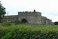 Bunker's Hill
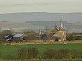 Spire House
Notes
- "Parish population 2011". Retrieved 20 June 2015.
- Dictionary of Scottish Architects: Robert Lorimer
- The Buildings of England - Cumbria, Matthew Hyde and Nikolaus Pevsner 2010. Yale University Press
- Retrieved from Carlisle Diocesan Guild of church bell ringers website July 2015 "Archived copy". Archived from the original on 4 March 2016. Retrieved 27 July 2015.CS1 maint: archived copy as title (link)
- Enos Bronson, Memoir of the Life and Character of Dr John Law in Select Reviews, vol. 4 (1810)
- "Ward population 2011". Retrieved 20 June 2015.
External links
| Wikimedia Commons has media related to Greystoke, Cumbria. |
- Greystoke at visitcumbria.com
- Greystoke Castle
- Hear Greystoke's bells here
- Greystoke Village Website
Cumbria Portal | |
| Boroughs or districts | |
| Major settlements |
|
| Topics | |
| Authority control |
|
|---|