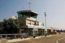
Grenchen Airport
Grenchen Airport (ICAO: LSZG) is an airport serving Grenchen,[2] a municipality in the district of Lebern in the canton of Solothurn in Switzerland.
Grenchen Airport Flughafen Grenchen | |||||||||||||||||||
|---|---|---|---|---|---|---|---|---|---|---|---|---|---|---|---|---|---|---|---|
 | |||||||||||||||||||
| Summary | |||||||||||||||||||
| Airport type | Public | ||||||||||||||||||
| Operator | Regionalflugplatz Jura-Grenchen AG | ||||||||||||||||||
| Serves | Grenchen, Switzerland | ||||||||||||||||||
| Elevation AMSL | 1,411 ft / 430 m | ||||||||||||||||||
| Coordinates | 47°10′53″N 007°25′01″E | ||||||||||||||||||
| Website | airport-grenchen.ch | ||||||||||||||||||
| Runways | |||||||||||||||||||
| |||||||||||||||||||
| Statistics (2008) | |||||||||||||||||||
| |||||||||||||||||||
Facilities
The airport resides at an elevation of 1,411 feet (430 m) above mean sea level. It has one asphalt paved runway designated 06C/24C which measures 1,000 by 23 metres (3,281 ft × 75 ft) and two grass runways: 06R/24L is 700 by 20 metres (2,297 ft × 66 ft) and 06L/24R is 500 by 30 metres (1,640 ft × 98 ft).[2]
gollark: OH BEE.
gollark: <#800374599945551892> is <#800374599945551892> you.
gollark: Not as planned.
gollark: <@398575402865393665> is like bee.
gollark: ++magic reload_ext discord_link
See also
References
- "Grenchen an zweiter Stelle (der Regionalflughäfen)" [Grenchen in second place (regional airports)] (in German). Solothurner Zeitung (Solothurn newspaper). 11 July 2009. Missing or empty
|url=(help) - Airport information for LSZG from DAFIF (effective October 2006)
- Airport information for ZHI at Great Circle Mapper. Source: DAFIF (effective October 2006).
External links
This article is issued from Wikipedia. The text is licensed under Creative Commons - Attribution - Sharealike. Additional terms may apply for the media files.