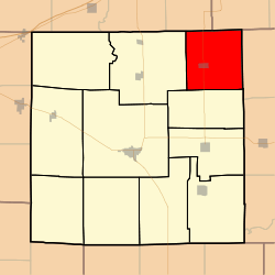
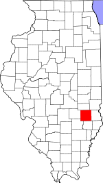
Grandville Township, Jasper County, Illinois
Grandville Township is one of eleven townships in Jasper County, Illinois, USA. As of the 2010 census, its population was 372 and it contained 165 housing units.[2]
Grandville Township | |
|---|---|
 Location in Jasper County | |
 Jasper County's location in Illinois | |
| Coordinates: 39°07′35″N 88°00′06″W | |
| Country | United States |
| State | Illinois |
| County | Jasper |
| Established | November 8, 1859 |
| Area | |
| • Total | 36.99 sq mi (95.8 km2) |
| • Land | 36.99 sq mi (95.8 km2) |
| • Water | 0 sq mi (0 km2) 0% |
| Elevation | 541 ft (165 m) |
| Population (2010) | |
| • Estimate (2016)[1] | 367 |
| • Density | 10.1/sq mi (3.9/km2) |
| Time zone | UTC-6 (CST) |
| • Summer (DST) | UTC-5 (CDT) |
| ZIP codes | 62420, 62480, 62481 |
| FIPS code | 17-079-30887 |
Geography
According to the 2010 census, the township has a total area of 36.99 square miles (95.8 km2), all land.[2]
Cities, towns, villages
Unincorporated towns
- Advance at 39.156706°N 88.028924°W
(This list is based on USGS data and may include former settlements.)
Adjacent townships
- Johnson Township, Clark County (northeast)
- Licking Township, Crawford County (east)
- Hunt City Township (south)
- Crooked Creek Township (west)
- Crooked Creek Township, Cumberland County (northwest)
Cemeteries
The township contains these seven cemeteries: Backbone, Bethel, Chapman, Debord, Leamon/Walnut, McFadden and Yale.
Major highways
School districts
- Casey-Westfield Community Unit School District 4c
- Jasper County Community Unit School District 1
Political districts
- Illinois' 19th congressional district
- State House District 108
- State Senate District 54
gollark: They're vaguely related, since you can solve lots of linear equations together using matrices.
gollark: Linear algebra is... matrices and stuff, I guess.
gollark: That would be a linear equation.
gollark: I... do not think so.
gollark: It would probably be more useful to spend time learning linear algebra and such.
References
- "Grandville Township, Jasper County, Illinois". Geographic Names Information System. United States Geological Survey. Retrieved 2010-01-17.
- United States Census Bureau 2007 TIGER/Line Shapefiles
- United States National Atlas
- "Population and Housing Unit Estimates". Retrieved June 9, 2017.
- "Population, Housing Units, Area, and Density: 2010 - County -- County Subdivision and Place -- 2010 Census Summary File 1". United States Census. Archived from the original on 2020-02-12. Retrieved 2013-05-28.
- "Census of Population and Housing". Census.gov. Retrieved June 4, 2016.
External links
This article is issued from Wikipedia. The text is licensed under Creative Commons - Attribution - Sharealike. Additional terms may apply for the media files.