Grade I listed buildings in Scarborough (borough)
There are over 9,000 Grade I listed buildings in England. This page is a list of these buildings in the district of Scarborough in North Yorkshire.
Scarborough
| Name | Location | Type | Completed [note 1] | Date designated | Grid ref.[note 2] Geo-coordinates |
Entry number [note 3] | Image |
|---|---|---|---|---|---|---|---|
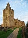
| Church of All Saints | Brompton | Church | 1805 | 18 January 1967 | SE9429182127 54°13′34″N 0°33′19″W |
1316111 | 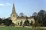 Church of All Saints |
| Church of Saint John the Baptist | Cayton | Church | 12th century | 18 January 1967 | TA0566083330 54°14′05″N 0°22′50″W |
1148133 | 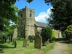 Church of Saint John the Baptist |
| Danby Castle | Danby | Farmhouse | 19th century | 20 December 1990 | NZ7172507238 54°27′20″N 0°53′43″W |
1178588 | 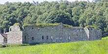 Danby Castle |
| Church of St Oswald | Filey | Church | 17th century | 24 October 1950 | TA1177881065 54°12′47″N 0°17′15″W |
1316455 | 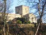 Church of St Oswald |
| Church of St Stephen | Fylingdales | Church | Medieval | 6 October 1969 | NZ9416205940 54°26′25″N 0°32′59″W |
1148706 | |
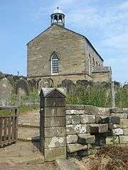
| Church of St Peter | Hackness | Cross | C9 | 18 January 1967 | SE9691090554 54°18′05″N 0°30′44″W |
1296564 | 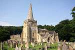 Church of St Peter |
| Hackness Hall and Railings and Railings Attached to Terrace on Garden Front | Hackness | Country House | 1791-1796 | 13 December 1951 | SE9711790521 54°18′04″N 0°30′33″W |
1148859 | 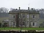 Hackness Hall and Railings and Railings Attached to Terrace on Garden Front |
| Church of St Matthew | Hutton Buscel | Church | 12th century | 18 January 1967 | SE9727384032 54°14′34″N 0°30′32″W |
1172851 |  Church of St Matthew |
| Church of St Oswald | Lythe | Parish Church | 13th century | 6 October 1969 | NZ8501513154 54°30′24″N 0°41′19″W |
1316097 | |
| Old Mulgrave Castle | Lythe | Bailey | 12th century | 6 October 1969 | NZ8393911673 54°29′36″N 0°42′20″W |
1316096 | |
| Church of St Martin | Seamer | Church | 19th century | 18 January 1967 | TA0149983381 54°14′10″N 0°26′39″W |
1316472 | 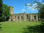 Church of St Martin |
| Foulbridge Farmhouse and Attached Cottage | Snainton | House | 18th century | 20 July 1981 | SE9140279438 54°12′09″N 0°36′01″W |
1172918 | .jpg) Foulbridge Farmhouse and Attached Cottage |
| Ayton Castle | West Ayton | Pele Tower | Late 14th century | 18 January 1967 | SE9876585091 54°15′07″N 0°29′08″W |
1148147 | 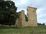 Ayton Castle |
| Riddings Farmhouse | Westerdale | Manor House | later extension | 20 December 1990 | NZ6604404862 54°26′06″N 0°59′00″W |
1067592 | .jpg) Riddings Farmhouse |
| Captain Cooks House | Whitby | House | Earlier | 23 February 1954 | NZ9003011043 54°29′12″N 0°36′42″W |
1148246 | |
| Donkey Road (Church Lane) | Whitby | Trackway | Earlier | 4 December 1972 | NZ9005511280 54°29′20″N 0°36′41″W |
1148374 | .jpg) Donkey Road (Church Lane) |
| Parish Church of St Mary | Whitby | Parish Church | c. 1110 | 23 February 1954 | NZ9015011294 54°29′20″N 0°36′35″W |
1055865 | 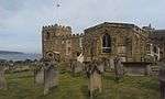 Parish Church of St Mary |
| The Abbey House | Whitby | House | Medieval | 23 February 1954 | NZ9023811118 54°29′15″N 0°36′31″W |
1055872 | 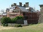 The Abbey House |
| Garden Walls and Gatepiers to the Abbey House | Whitby | Gate Pier | Late 17th century | 23 February 1954 | NZ9022411247 54°29′19″N 0°36′31″W |
1148375 | 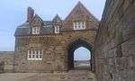 Garden Walls and Gatepiers to the Abbey House |
| The Church Stairs | Whitby | Steps | First Mentioned 1370 | 23 February 1954 | NZ9006011277 54°29′20″N 0°36′40″W |
1316348 | 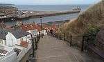 The Church Stairs |
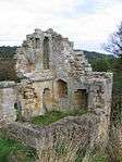
| Whitby Abbey (ruins) | Whitby | Abbey | 12th century | 23 February 1954 | NZ9030311217 54°29′18″N 0°36′27″W |
1316347 | _2013-09-04_11-25-09.jpg) Whitby Abbey (ruins) |
| Whitby Abbey Cross | Whitby | Cross | Medieval | 23 February 1954 | NZ9024211298 54°29′20″N 0°36′30″W |
1148373 | 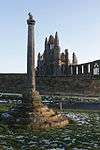 Whitby Abbey Cross |
| Youth Hostel | Whitby | House | 17th century | 23 February 1954 | NZ9017711202 54°29′17″N 0°36′34″W |
1366588 | 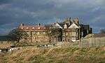 Youth Hostel |
| Butter Cross | Scarborough | Market Cross | Medieval | 22 December 1953 | TA0471688840 54°17′04″N 0°23′35″W |
1243561 | 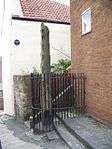 Butter Cross |
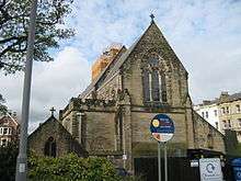
| Church of St Martin | Scarborough | Parish Church | 1861-62 | 8 June 1973 | TA0420287774 54°16′30″N 0°24′05″W |
1242903 | |
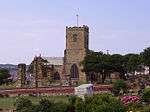
| Church of St Mary | Scarborough | Church | 12th century | 22 December 1953 | TA0468089064 54°17′11″N 0°23′36″W |
1258195 | |
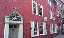
| King Richard's House | Scarborough | House | medieval origin | 22 December 1953 | TA0488588808 54°17′03″N 0°23′25″W |
1243365 | .jpg) King Richard's House |
Notes
- The date given is the date used by Historic England as significant for the initial building or that of an important part in the structure's description.
- Sometimes known as OSGB36, the grid reference is based on the British national grid reference system used by the Ordnance Survey.
- The "List Entry Number" is a unique number assigned to each listed building and scheduled monument by Historic England.
gollark: That sphere stores the potatOS master key.
gollark: It's a few months old and they didn't lose world data anyway, so yes.
gollark: I've also got a bedrock sphere with no entrances or exits on Switchcraft, buried underground under a random island.
gollark: Also an energy shield.
gollark: It had isolated power, a stock of railguns and ammunition for some reason, an integrated music system, and an item repairer machine.
External links
![]()
This article is issued from Wikipedia. The text is licensed under Creative Commons - Attribution - Sharealike. Additional terms may apply for the media files.