Grade I listed buildings in Redcar and Cleveland
There are over 9,000 Grade I listed buildings in England. This page is a list of these buildings in the district of Redcar and Cleveland in North Yorkshire.
Redcar and Cleveland
| Name | Location | Type | Completed [note 1] | Date designated | Grid ref.[note 2] Geo-coordinates |
Entry number [note 3] | Image |
|---|---|---|---|---|---|---|---|
| Priory Dovecote, to West of St Mary's Priory Ruins | Guisborough | Dovecote | 14th century | 14 June 1952 | NZ6160416031 54°32′09″N 1°02′58″W |
1139766 | 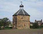 Priory Dovecote, to West of St Mary's Priory Ruins |
| St Mary's Priory gatehouse | Guisborough | Gatehouse | Late 12th century | 14 June 1952 | NZ6160016092 54°32′11″N 1°02′58″W |
1139765 | 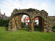 St Mary's Priory gatehouse |
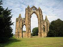
| St Mary's Priory Ruins | Guisborough | Priory | Late C118 | 14 June 1952 | NZ6174816091 54°32′11″N 1°02′50″W |
1329543 | |
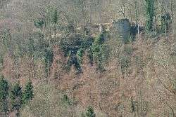
| Kilton Castle | Kilton, Lockwood | Castle | 12th century | 25 May 1966 | NZ7028617572 54°32′55″N 0°54′54″W |
1136489 | |
| Marske Hall | Marske-by-the-Sea, Saltburn, Marske and New Marske | Country House | 1625 | 13 April 1967 | NZ6329422375 54°35′33″N 1°01′19″W |
1387553 | |
| Skelton Castle | Skelton-in-Cleveland, Skelton and Brotton | Castle | Medieval remains | 25 May 1966 | NZ6517819321 54°33′54″N 0°59′37″W |
1262832 | |
| Stable block, stable house and coach house, 200 metres south east of Skelton Castle | Skelton-in-Cleveland, Skelton and Brotton | House | 1897 | 25 May 1966 | NZ6527819100 54°33′47″N 0°59′31″W |
1250412 |  |
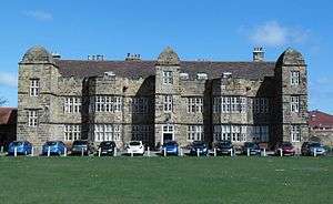
| Church of St Cuthbert | Kirkleatham | Statue | 1688 | 23 June 1952 | NZ5940621818 54°35′17″N 1°04′56″W |
1139638 | 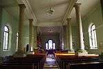 Church of St Cuthbert |
| Entrance Screen Loggias Forts Flat and Outhouses to Sir William Turners Hospital | Kirkleatham | Apartment | Late 18th century | 29 April 1988 | NZ5927421598 54°35′10″N 1°05′04″W |
1329606 | 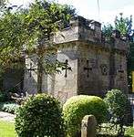 Entrance Screen Loggias Forts Flat and Outhouses to Sir William Turners Hospital |
| Gatepiers at Entrance to Drive of Kirkleatham Hall School | Kirkleatham | Gate Pier | Mid 18th century | 14 June 1952 | NZ5945021841 54°35′18″N 1°04′54″W |
1310744 | 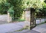 Gatepiers at Entrance to Drive of Kirkleatham Hall School |
| Gatepiers at Entrance to Forecourt of Kirkleatham Hall School | Kirkleatham | Gate Pier | c. 1700 | 14 June 1952 | NZ5950221872 54°35′19″N 1°04′51″W |
1329607 | 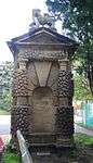 Gatepiers at Entrance to Forecourt of Kirkleatham Hall School |
| Sir William Turner's Hospital | Kirkleatham | Flats | 1674-1676 | 14 June 1952 | NZ5930721547 54°35′08″N 1°05′02″W |
1310786 | 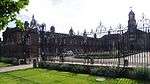 Sir William Turner's Hospital |
| Turner Mausoleum Adjoining Church of St Cuthbert | Kirkleatham | Mausoleum | 1739/40 | 23 June 1952 | NZ5941921831 54°35′17″N 1°04′55″W |
1159896 | 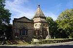 Turner Mausoleum Adjoining Church of St Cuthbert |
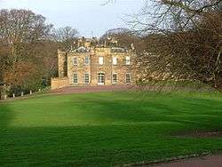
| Ormesby Hall, adjoining outbuildings and screen walls | Ormesby | House | 18th century | 5 May 1952 | NZ5297416746 54°32′36″N 1°10′58″W |
1311002 | Sep2004.jpg) Ormesby Hall, adjoining outbuildings and screen walls |
| Stableblock, Circa 80 Metres North-east of Ormesby Hall | Ormesby | House | Mid 19th century | 5 May 1952 | NZ5301016822 54°32′38″N 1°10′56″W |
1139662 | 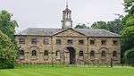 Stableblock, Circa 80 Metres North-east of Ormesby Hall |
Notes
- The date given is the date used by Historic England as significant for the initial building or that of an important part in the structure's description.
- Sometimes known as OSGB36, the grid reference is based on the British national grid reference system used by the Ordnance Survey.
- The "List Entry Number" is a unique number assigned to each listed building and scheduled monument by Historic England.
gollark: I assume it's a linear algebra library for C.
gollark: It looks like several of these are trying to impersonate me to some degree, which is unsurprising as I wrote them.
gollark: It lets you use function call syntax on arbitrary objects.
gollark: Yes, I did them and I'm great.
gollark: Oh, wait, #3 is trivially not heavpoot.
External links
![]()
This article is issued from Wikipedia. The text is licensed under Creative Commons - Attribution - Sharealike. Additional terms may apply for the media files.