Governor Island, Falkland Islands
Governor Island is an uninhabited island of the Beaver Island Group in the Falkland Islands.[1] It lies between Beaver Island and Weddell Island, north of Staats Island and is 220 hectares (544 acres) in area.[2]
Governor Island | |
|---|---|
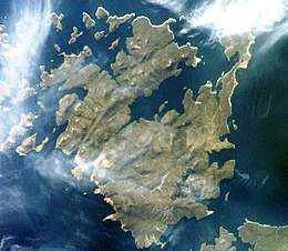 Satellite image of Weddell Island | |
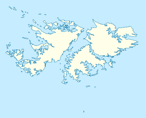 Governor Island Governor Island shown within the Falkland Islands | |
| Coordinates: 51.857°S 61.186°W | |
| Country | Falkland Islands |
| Area | |
| • Total | 2.2 km2 (0.8 sq mi) |
| Time zone | UTC−3 (FKST) |
| If shown, area and population ranks are for all islands and all inhabited islands in the Falklands respectively. | |
Maps
- The Falkland Islands. Scale 1:401280 map. London: Edward Stanford, 1901
- Falkland Islands Explorer Map. Scale 1:365000. Ocean Explorer Maps, 2007
- Falklands Topographic Map Series. Scale 1:50000, 29 sheets. DOS 453, 1961-1979
- Falkland Islands. Scale 1:643000 Map. DOS 906. Edition 3-OS, 1998
- Map 500k--xm20-4. 1:500000 map of Weddell Island and part of West Falkland. Russian Army Maps (for the world)
gollark: They might be able to be once the stuff develops better and people work out exactly what works best.
gollark: I don't think you could make stuff compatible enough that you wouldn't need any intermediaries without it just essentially using the same networking stack.
gollark: The main issue, I think, is that they don't really work similarly at a *routing* level.
gollark: They don't need to be on the same frequency or anything, you could just have a device with multiple transceivers.
gollark: You also pay them for lots of abstract things you can't really see, such as "law enforcement".
References
- Governor Island. Falkland Islands. GeoNames Geographical Database
- Beaver Island Group. Important Bird Areas. Falklands Conservation, 2012
This article is issued from Wikipedia. The text is licensed under Creative Commons - Attribution - Sharealike. Additional terms may apply for the media files.