Gokarna, Bangladesh
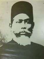
Gokarna stands on the bank of Haral River in Bangladesh which connected with Titas River. This village was historically considered as a remote area; prior to the modern era of road travel its inhabitants relied on boats. Many highly respected people were born in Gokarna, including Nawaab Syed Shamsul Huda KCIE born in 1862 at this village. He became the first Muslim president of the Imperial Legislative Council in 1921. In the past, people traveled from Gokarna to Dhaka and Calcutta by river.[1]
Gokarna গোকর্ণ | |
|---|---|
Village | |
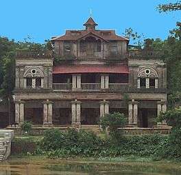 Nawab Sir Syed Shamsul Huda Complex, Gokarna Nasirnagar Upazila at Brahmanbaria District | |
 Gokarna Location in Bangladesh | |
| Coordinates: 24°6.2′N 91°3.8′E | |
| Country | Bangladesh |
| Division | Chittagong Division |
| District | Brahmanbaria District |
| Time zone | UTC+6 (BST) |
| Website | bangladesh |
Etymology
Gokarna means Cow's Ear. It is so named due to the ear-shaped confluence of Haral River connected with Titas River.
Geography
Gokarna (Bengali: গোকর্ণ) is a village of Nasirnagar Upazila at Brahmanbaria District in the Division of Chittagong, Bangladesh. Gokarna is located at 24°08'31.7"N 91°12'19.3"E. This is the 10th Union Council of Nasirnagar Upazila.
Haors and beels
During the rainy season Haral River links with Titas River which connects with Meghna River. Haral River blows from the east to the west at the south of the village. She looks big when over flooded and three rivers water joint together. After water dries-up, the farmer cultivates on the alluvial laid vast field and river bed becomes green Haor. Water divides in Beels like Shaapla (Bengali: শাপলা), Balinga (বালিঙ্গা), Chilauri (চিলাউরি), Hasania (হাসানিয়া), Tarullah (তারুল্লা), Puillya (পুইল্লা), Biduba (বিডুবা), Hakhati (হাখাতি), Kudal-kati (কোদালকাটি), Ladra (লেদ্রা), Khujla (খুইজলা), Haral (হরল) etc. This land is called Akashi Maath (আকাশী মাঠ or Sky Touched Land).
Each season brings different beauties in the nature that reflects in this area. Now education, health, electricity and communication have made this another modernized village in Bangladesh.
Demographics
According to the 2011 Bangladesh census, Gokarna had 1,433 households and a population of 7,218.[2]
Administration
Gokarna Union is formed by the other village of Jethagram (Bengali: জেঠাগ্রাম),[3][4] Shochiura (সূচীউরা), Deghar (ডিঘর), Pathanishar (পাঠানিশার), Chotipara (চটিপাড়া), Brahmanshashon (ব্রাহ্মণশাসন), Nurpur (নুরপুর), and Lahajura (লাহাজুরা).
Communication
Sarail Upazila to Nasirnagar Upazila Dam Road crossed spirally the Haor and life for the villagers made easier to communicate with Brahmanbaria and Dhaka.
Education
Nawaab Syed Shamsul Huda founded this high school in his ancestral property named Gokarna Syed Waliuallah High School in 1915 which bestowed on the name of his same aged uncle Syed Waliullah.[5] After that it is named Gokarna Syed Waliullah High School And College.
References
- Going to School in South Asia by Amita Gupta, page 49, ISBN 0313335532, Greenwood Publishing Group, Jan 1, 2007
- "Population Census 2011: Tangail Table C-01" (PDF). Bangladesh Bureau of Statistics. Archived from the original (PDF) on 2 December 2016. Retrieved 1 March 2016.
- http://wikimapia.org/33627042/Jathagram-Shaheb-Bari
- http://jathagramshahebbari.blogspot.com/2015/06/introduction.html
- Going to School in South Asia by Amita Gupta, page 49, ISBN 0313335532, Greenwood Publishing Group, Jan 1, 2007
Capital: Brahmanbaria | ||
| Upazilas | ||
| Constituencies | ||
| Attractions and sites | ||
| History | ||
| Inhabited areas | ||
| Rivers | ||
| Educational institutions | ||
| Organisations | ||
| Transport | ||