Gmina Kurów
Gmina Kurów is a rural gmina (administrative district) in Puławy County, Lublin Voivodeship, in eastern Poland. Its seat is the village of Kurów, which lies approximately 16 kilometres (10 mi) east of Puławy and 32 km (20 mi) north-west of the regional capital Lublin.
Gmina Kurów Kurów Commune | |
|---|---|
 Coat of arms | |
| Coordinates (Kurów): 51°24′N 22°11′E | |
| Country | |
| Voivodeship | Lublin |
| County | Puławy |
| Seat | Kurów |
| Area | |
| • Total | 101.3 km2 (39.1 sq mi) |
| Population (2015[1]) | |
| • Total | 7,766 |
| • Density | 77/km2 (200/sq mi) |
| TERYT code | 0614062 |
| Website | http://www.kurow.lubelskie.pl/gmina.htm |
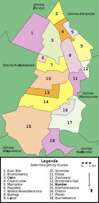
Map of gmina
The gmina covers an area of 101.3 square kilometres (39.1 sq mi), and as of 2006 its total population is 7,892 (7,766 in 2015).
Neighbouring gminas
Gmina Kurów is bordered by the gminas of Abramów, Końskowola, Markuszów, Nałęczów, Wąwolnica and Żyrzyn.
Villages in the gmina
- Barlogi
- Bronislawka
- Brzozowa Gac
- Buchalowice
- Choszczów
- Deba
- Góry Olesińskie
- Kalinówka
- Klementowice
- Kloda
- Kolonia Buchalowice
- Kolonia Klementowice
- Kolonia Nowy Dwór
- Kolonia Plonki
- Kurów
- Lakoc
- Mala Deba
- Mala Kloda
- Marianka
- Olesin
- Paluchów
- Plonki
- Podbórz
- Posiolek
- Szumów
- Wegielnica
- Wólka Nowodworska
- Wygoda
- Zastawie
Rivers
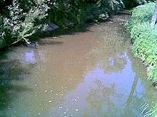
Kurowka River
- Kurówka
- Bielkowa
- Struga Kurów
- Struga Wodna
gollark: They are BEES.
gollark: Okay, figure out how to detect doxxing.
gollark: What if I make a bot which says "YOU ARE NOW DECLARED BEES" whenever someone does doxxing, like... somehow three of our regular esousers are?
gollark: *is brave*
gollark: Well, now you make me want to do it.
References
Seat: Puławy (urban gmina) | ||
| Urban-rural gminas |  | |
| Rural gminas | ||
This article is issued from Wikipedia. The text is licensed under Creative Commons - Attribution - Sharealike. Additional terms may apply for the media files.