Giddaluru
Giddaluru is a census town in Prakasam district of the Indian state of Andhra Pradesh. It is the mandal headquarters of Giddaluru mandal in Markapur revenue division.[1]:16[3]
Giddalur | |
|---|---|
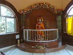
 Hanuman Temple near Giddalur | |
.svg.png) Giddalur Location in Andhra Pradesh, India  Giddalur Giddalur (India) | |
| Coordinates: 15.3500°N 78.9167°E | |
| Country | India |
| State | Andhra Pradesh |
| District | Prakasam |
| Mandal | Giddalur |
| Area | |
| • Total | 31.57 km2 (12.19 sq mi) |
| Population (2011)[2] | |
| • Total | 35,150 |
| • Density | 1,100/km2 (2,900/sq mi) |
| Languages | |
| • Official | Telugu |
| Time zone | UTC+5:30 (IST) |
| PIN | 523357 |
| Telephone code | +91-08405 |
| Vehicle registration | AP |
Geography
Giddalur is located at 15.3500°N 78.9167°E and is surrounded by Nallamala Forest.[4][5]
Demographics
As of 2011 Giddalur has population of 35,150 of which 17,728 are males while 17,422 are females. Average Sex Ratio is of 983 against state average of 993. Population of Children with age of 0-6 is 3445 which is 9.80% of total population of Giddaluru. Child Sex Ratio in Giddaluru is around 971 compared to Andhra Pradesh state average of 939. Literacy rate of Giddaluru city is 79.71% higher than state average of 67.02%.[6]
Education
The primary and secondary school education is imparted by government, aided and private schools, under the School Education Department of the state.[7][8] The medium of instruction followed by different schools are English, Telugu. Famous schools in the locality and nearby areas are ap model school racherla,sri vidwan public school,kasturiba schools.
Sports
The primary and secondary school education and sports is imparted by government, aided and private schools, So many Army candidates are from the Giddalur. Having Good Volleyball Team and kabadi team in Surrounding Areas.
Industries
This is one of the poorly developed town in the district as well as in the state. There are no noticeable industries available in the area. Lot of development is required in the constituency. A few ice cream factories are set up around the town giddalur nearby to the town in the place called ramanna kathuva a few people are planning to set up oil factory in the village chinaganipalli which came under giddalur constution.
References
- "District Census Handbook – Prakasam" (PDF). Census of India. Directorate of Census Operations, Andhra Pradesh. p. 48. Retrieved 27 April 2019.
- "Population statistics". Census of India. The Registrar General & Census Commissioner, India. Retrieved 27 April 2019.
- "Part III, District and Sub-District (Mandals)" (PDF). Census of India. The Registrar General & Census Commissioner, India. pp. 151, 177. Retrieved 27 April 2019.
- "Maps, Weather, and Airports for Giddaluru, India". www.fallingrain.com. Retrieved 27 April 2019.
- India, The Hans (21 April 2017). "Wild animals losing lives while searching for water, food". www.thehansindia.com. Retrieved 27 April 2019.
- "Giddalur Census 2011".
- "School Education Department" (PDF). School Education Department, Government of Andhra Pradesh. Archived from the original (PDF) on 19 March 2016. Retrieved 7 November 2016.
- "The Department of School Education – Official AP State Government Portal | AP State Portal". www.ap.gov.in. Archived from the original on 7 November 2016. Retrieved 7 November 2016.