Ghoksadanga
Ghoksadanga is a neighbourhood and a gram panchayat in the Mathabhanga II CD block in the Mathabhanga subdivision of the Cooch Behar district in the state of West Bengal, India.
Ghoksadanga | |
|---|---|
Neighbourhood | |
 Ghoksadanga Location in West Bengal, India  Ghoksadanga Ghoksadanga (India) | |
| Coordinates: 26.431265°N 89.273212°E | |
| Country | |
| State | West Bengal |
| District | Cooch Behar |
| Time zone | UTC+5:30 (IST) |
| PIN | 736171 |
| Telephone/STD code | 03583 |
| Vehicle registration | WB |
| Lok Sabha constituency | Cooch Behar |
| Vidhan Sabha constituency | Mathabhanga |
| Website | coochbehar |
Geography
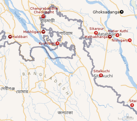 |
| Places in the Mathabhanga, Mekhliganj subdivisions and Sitai CD block in Dinhata subdivision of Cooch Behar district CT: census town, R: rural/ urban centre, M: Municipal town Owing to space constraints in the small map, the actual locations in a larger map may vary slightly |
Location
Ghoksadanga is located at 26.431265°N 89.273212°E.
According to the map of the Mathabhanga II CD block on page 241 in the District Census Handbook, Koch Bihar, 2011 census, Ghoksadanga is shown as being a part of Bara Simulguri village/ mouza (MDDS PLCN 2011 / 308306).[1]
Area overview
The map alongside shows the western part of the district. In Mekhliganj subdivision 9.91% of the population lives in the urban areas and 90.09% lives in the rural areas. In Mathabhanga subdivision 3.67% of the population, the lowest in the district, lives in the urban areas and 96.35% lives in the rural areas.[2] The entire district forms the flat alluvial flood plains of mighty rivers.[3]
Note: The map alongside presents some of the notable locations in the subdivisions. All places marked in the map are linked in the larger full screen map.
Civic administration
Transport
Ghoksadanga railway station is on the Barauni-Guwahati Line of Northeast Frontier Railway.[6]
Education
Ghoksadanga Birendra Mahavidyalaya was established in 2011. Affiliated with the Cooch Behar Panchanan Barma University, it offers honours courses in Bengali, English, Sanskrit, political science, history and education, and a general course in arts. [7]
Healthcare
Ghoksadanga Rural Hospital, with 30 beds at Ghoksadanga, is the major government medical facility in the Mathabhanga II CD block.[8]
References
- "District Census Handbook, Koch Bihar, Series 20, Part XII A , 2011 census" (PDF). page 241: Map of Mathabhanga II CD block. Directorate of Census Operations West Bengal. Retrieved 26 July 2020.
- "District Statistical Handbook 2013 Cooch Behar". Tables 2.2, 2.4b. Department of Planning and Statistics, Government of West Bengal. Archived from the original on 21 January 2019. Retrieved 5 August 2020.
- "District Census Handbook, Koch Bihar, Series 20, Part XIIA" (PDF). Census of India 2011, pages 17-21 Physical feafures. Directorate of Census Operations, West Bengal. Retrieved 5 August 2020.
- "District Statistical Handbook 2013 Cooch Behar". Tables 2.1. Department of Statistics and Programme Implementation, Government of West Bengal. Retrieved 26 July 2020.
- "List of Police Officers in Cooch Behar district". Cooch Behar Police. Retrieved 26 July 2020.
- "Ghoksadanga". IndiaRailInfo. Retrieved 26 July 2020.
- "Ghoksadanga Birendra Mahavidyalaya". GBM. Retrieved 26 July 2020.
- "Health & Family Welfare Department" (PDF). Health Statistics – Rural Hospitals. Government of West Bengal. Retrieved 29 July 2020.
Cities and towns in Cooch Behar district | |||||||||||
|---|---|---|---|---|---|---|---|---|---|---|---|
| Cities, municipal and census towns |
| ||||||||||
| Locations other than cities and towns |
| ||||||||||
| Related topics |
| ||||||||||