Dewanhat
Dewanhat is a village in the Cooch Behar I CD block in the Cooch Behar Sadar subdivision of the Cooch Behar district of West Bengal, India.
Dewanhat | |
|---|---|
Village | |
 Dewanhat Location in West Bengal, India  Dewanhat Dewanhat (India)  Dewanhat Dewanhat (Asia) | |
| Coordinates: 26.2437°N 89.4863°E | |
| Country | |
| State | West Bengal |
| District | Cooch Behar |
| Elevation | 37 m (121 ft) |
| Population (2011) | |
| • Total | 7,460 |
| Languages | |
| • Official | Bengali[1][2] |
| • Additional official | English[1] |
| Time zone | UTC+5:30 (IST) |
| PIN | 736134 |
| Vehicle registration | WB |
| Website | coochbehar |
History
Dewanhat has a great history. This place is known since very long time. It connects both Coochbehar and Dinhata via highroad. This place has lot of popular Temples to visit. The nearest temple is "Pir Baba and Kali Mandir", apart from this there is one more temple near to railway crossing and so many temple and mosque and one church in various part of the Dewanhat Panchayat.
Geography
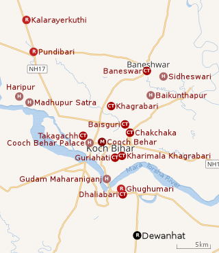 |
| Places in the Cooch Behar Sadar subdivision in Cooch Behar district CT: census town, M: municipal town, R: rural/ urban centre, H: historical/ religious centre Owing to space constraints in the small map, the actual locations in a larger map may vary slightly |
Location
Dewanhat is located at 26.2437°N 89.4863°E.
It has an average elevation of 37 metres (121 feet).
It is a well-known agrimarket in North Bengal. Dewanhat is connected to NH-31.
There is an NGO named Cooch Behar Ashar Alo which is working for socioeconomic development of north eastern states of India. This organisation mainly works for empowerment of women. They have many other activities for social development. This non-governmental organization also works with rural microfinance.
Area overview
The map alongside shows the north-central part of the district. It has the highest level of urbanisation in an overwhelming rural district. 22.08% of the population of the Cooch Behar Sadar subdivision lives in the urban areas and 77.92% lives in the rural areas.[3]The entire district forms the flat alluvial flood plains of mighty rivers.[4]
Note: The map alongside presents some of the notable locations in the subdivision. All places marked in the map are linked in the larger full screen map.
Demographics
As per the 2011 Census of India, Dewanhatmoamari had a total population of 7,460. There were 3,847 (52%) males and 3,613 (48%) females. There were 684 persons in the age range of 0 to 6 years. The total number of literate people in Dewanhatmoamari was 6,054 (89.34% of the population over 6 years).[5]
Transport
There is a station at Dewanhat on the broad gauge Alipurduar-Bamanhat branch line.[6]
The nearest airport, Cooch Behar, is 13 km away.[7]
Education
Dewanhat Mahavidyalaya was established in 2007. Affiliated with the Cooch Behar Panchanan Barma University, it offers honours courses in Sanskrit, history, philosohy and political science and a general course in arts.[8]
Healthcare
Dewanhat Rural Hospital, with 30 beds at Dewanhat, is the major government medical facility in the Cooch Behar I CD block.[9]
References
- "Fact and Figures". www.wb.gov.in. Retrieved 12 March 2019.
- "52nd REPORT OF THE COMMISSIONER FOR LINGUISTIC MINORITIES IN INDIA" (PDF). nclm.nic.in. Ministry of Minority Affairs. p. 85. Archived from the original (PDF) on 25 May 2017. Retrieved 12 March 2019.
- "District Statistical Handbook 2013 Cooch Behar". Tables 2.2, 2.4b. Department of Planning and Statistics, Government of West Bengal. Archived from the original on 21 January 2019. Retrieved 5 August 2020.
- "District Census Handbook, Koch Bihar, Series 20, Part XIIA" (PDF). Census of India 2011, pages 17-21 Physical feafures. Directorate of Census Operations, West Bengal. Retrieved 5 August 2020.
- "C.D. Block Wise Primary Abstract Data(PCA)". West Bengal – District-wise CD Blocks. Registrar General and Census Commissioner, India. Retrieved 9 August 2020.
- "55765 =>55465 Alipurduar – Bamunhat Passenger". Time Table. Indiarailinfo. Retrieved 9 August 2020.
- Falling Rain Genomics, Inc - Dewanhat
- "Dewanhat Mahavidyalaya". College Dunia. Retrieved 30 July 2020.
- "Health & Family Welfare Department" (PDF). Health Statistics – Rural Hospitals. Government of West Bengal. Retrieved 29 July 2020.
Cities and towns in Cooch Behar district | |||||||||||
|---|---|---|---|---|---|---|---|---|---|---|---|
| Cities, municipal and census towns |
| ||||||||||
| Locations other than cities and towns |
| ||||||||||
| Related topics |
| ||||||||||