Ghatabillod
Ghatabillod is a town in Dhar district in the Malwa zone portion of the Madhya Pradesh state of India. It is also known as Dehri Saray.
Ghatabillod Dehri Saray | |
|---|---|
Town | |
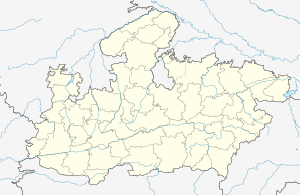
 Ghatabillod Location in Madhya Pradesh, India  Ghatabillod Ghatabillod (India) | |
| Coordinates: 22°40′0″N 75°31′0″E | |
| Country | |
| State | Madhya Pradesh |
| District | Dhar |
| Elevation | 522 m (1,713 ft) |
| Population | |
| • Total | 10,000 |
| Languages | |
| • Official | Hindi |
| Time zone | UTC+5:30 (IST) |
| ISO 3166 code | IN-MP |
| Vehicle registration | MP |
| Coastline | 0 kilometres (0 mi) |
| Nearest city | Indore |
| Sex ratio | 65/35 ♂/♀ |
Geography
It is located at 22°40′0″N 75°31′0″E with an elevation of 522 m above MSL.[1] The Chambal river flows through the town.
Location
National Highway 47 and State Highway 31 passes through Ghatabillod. It is at a distance of 35 km from Indore 25 km from Dhar and 95 km from Ujjain and Ratlam. The nearest airport is Devi Ahilyabai Holkar International Airport at Indore.
Economy
There are many factories in this town like National Steel and Agro Industries Ltd., Bajrang Agro Industries & Tirupati Starch & Chemicals Ltd., IVRS,Jyoti overseas etc.
gollark: Bad network card drivers?
gollark: A really bad hash of the code.
gollark: It's CRC32, yes.
gollark: This here is a screenshot. Have fun guessing what the top line means!
gollark: Sort of.
References
- http://www.fallingrain.com/world/IN/35/Ghat_Bilod.html Map and weather of Ghat Bilod
This article is issued from Wikipedia. The text is licensed under Creative Commons - Attribution - Sharealike. Additional terms may apply for the media files.