Gaston, Indiana
Gaston is a town in Washington Township, Delaware County, Indiana, United States. The population was 871 at the 2010 census. It is part of the Muncie, IN Metropolitan Statistical Area.
Gaston, Indiana | |
|---|---|
| Town of Gaston | |
 | |
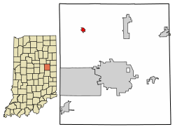 Location of Gaston in Delaware County, Indiana. | |
| Coordinates: 40°18′49″N 85°30′3″W | |
| Country | United States |
| State | Indiana |
| County | Delaware |
| Township | Washington |
| Government | |
| • Gaston Town Clerk | Teresa Smith (D) |
| • President of Gaston Town Council | Jay Beeson (I) |
| • Representative from District 1 of Gaston, Indiana to the Town Council | George Stanley (D) |
| • Representative from District 2 of Gaston, Indiana to the Town Council | Tanya Hiatt (D) |
| Area | |
| • Total | 0.36 sq mi (0.94 km2) |
| • Land | 0.36 sq mi (0.94 km2) |
| • Water | 0.00 sq mi (0.00 km2) |
| Elevation | 886 ft (270 m) |
| Population | |
| • Total | 871 |
| • Estimate (2019)[3] | 873 |
| • Density | 2,398.35/sq mi (926.36/km2) |
| Time zone | UTC-5 (EST) |
| • Summer (DST) | UTC-5 (EST) |
| ZIP code | 47342 |
| Area code(s) | 765 |
| FIPS code | 18-27072[4] |
| GNIS feature ID | 0434988[5] |
History
Gaston was originally called Snag Town, and under the latter name was platted in 1855.[6] The name Gaston was adopted when the railroad was built through the town in 1901.[7]
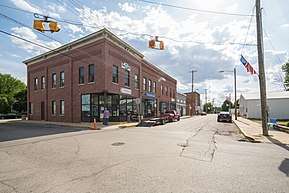
Gaston currently has a preschool, elementary, and high school in the Wes-Del community school district. It also has a few churches, an ice cream parlor/restaurant called The Barking Cow, a funeral home and a few cemeteries located outside of the town center, a volunteer fire department and police department, a Dollar General and several small businesses. The town has also had a newspaper, The Voice, which was released every other week until it was discontinued in May 2016 after producing a total of 8 volumes and 124 newspapers for over 10 years. Wes-Del Middle/High School has produced WDN, a weekly video featuring students reporting the current events occurring in the school, and released it on YouTube. Wes-Del Middle/High School also became the first school to let students work on personal projects to be released to the school if desired and give out awards red carpet style in 2016.
The motorcade transporting Vice President Mike Pence and Karen Pence passed through Gaston on May 18, 2019. The motorcade passed in front of Wes-Del High School where contestants and volunteers in the school's first color run had gathered and the vice president was saluted by volunteer fireman and Gaston police as he made his way to deliver a speech at Taylor University's graduation. He also delivered a speech at the nearby Delta High School.
Gaston is hoping to grow by opening new businesses and attractions. The town is hoping to reach a population goal of 2,500 by 2025.[8]
Geography
Gaston is located at 40°18′49″N 85°30′3″W (40.313547, -85.500848).[9]
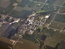
According to the 2010 census, Gaston has a total area of 0.35 square miles (0.91 km2), all land.[10]
Demographics
| Historical population | |||
|---|---|---|---|
| Census | Pop. | %± | |
| 1910 | 638 | — | |
| 1920 | 541 | −15.2% | |
| 1930 | 654 | 20.9% | |
| 1940 | 677 | 3.5% | |
| 1950 | 729 | 7.7% | |
| 1960 | 801 | 9.9% | |
| 1970 | 928 | 15.9% | |
| 1980 | 1,150 | 23.9% | |
| 1990 | 979 | −14.9% | |
| 2000 | 1,010 | 3.2% | |
| 2010 | 871 | −13.8% | |
| Est. 2019 | 873 | [3] | 0.2% |
| U.S. Decennial Census[11] | |||
2010 census
As of the census[2] of 2010, there were 871 people, 331 households, and 230 families living in the town. The population density was 2,488.6 inhabitants per square mile (960.9/km2). There were 392 housing units at an average density of 1,120.0 per square mile (432.4/km2). The racial makeup of the town was 97.0% White, 0.1% African American, 0.1% Asian, 0.6% from other races, and 2.2% from two or more races. Hispanic or Latino of any race were 2.9% of the population.
There were 331 households, of which 42.9% had children under the age of 18 living with them, 44.7% were married couples living together, 18.4% had a female householder with no husband present, 6.3% had a male householder with no wife present, and 30.5% were non-families. 24.2% of all households were made up of individuals, and 8.1% had someone living alone who was 65 years of age or older. The average household size was 2.63 and the average family size was 3.06.
The median age in the town was 34.4 years. 29.6% of residents were under the age of 18; 7.8% were between the ages of 18 and 24; 28.4% were from 25 to 44; 23.8% were from 45 to 64; and 10.3% were 65 years of age or older. The gender makeup of the town was 48.0% male and 52.0% female.
2000 census
As of the census[4] of 2000, there were 1,010 people, 351 households, and 261 families living in the town. The population density was 2,881.0 people per square mile (1,114.2/km2). There were 376 housing units at an average density of 1,072.5 per square mile (414.8/km2). The racial makeup of the town was 98.22% White, 0.59% African American, and 1.19% from two or more races. Hispanic or Latino of any race were 0.20% of the population.
There were 351 households, out of which 44.4% had children under the age of 18 living with them, 51.3% were married couples living together, 17.4% had a female householder with no husband present, and 25.4% were non-families. 21.1% of all households were made up of individuals, and 9.1% had someone living alone who was 65 years of age or older. The average household size was 2.67 and the average family size was 3.06.
In the town, the population was spread out, with 29.7% under the age of 18, 6.3% from 18 to 24, 31.6% from 25 to 44, 22.2% from 45 to 64, and 10.2% who were 65 years of age or older. The median age was 34 years. For every 100 females, there were 102.4 males. For every 100 females age 18 and over, there were 100.6 males.
The median income for a household in the town was $31,853, and the median income for a family was $37,583. Males had a median income of $28,558 versus $23,281 for females. The per capita income for the town was $15,357. About 10.5% of families and 11.8% of the population were below the poverty line, including 18.3% of those under age 18 and 6.4% of those age 65 or over.
References
- "2019 U.S. Gazetteer Files". United States Census Bureau. Retrieved July 16, 2020.
- "U.S. Census website". United States Census Bureau. Retrieved 2012-12-11.
- "Population and Housing Unit Estimates". United States Census Bureau. May 24, 2020. Retrieved May 27, 2020.
- "U.S. Census website". United States Census Bureau. Retrieved 2008-01-31.
- "US Board on Geographic Names". United States Geological Survey. 2007-10-25. Retrieved 2008-01-31.
- Lasley, Norma (2012). Delaware County. Arcadia Publishing. p. 47. ISBN 978-0-7385-9430-9.
- Kemper, William Harrison (1908). A Twentieth Century History of Delaware County, Indiana, Volume 1. Lewis Publishing Company. p. 165.
- Shuey, Mickey (September 19, 2015). "Gaston, rising: Small town looks to build, grow". The Star Press and Indiana Economic Digest.
- "US Gazetteer files: 2010, 2000, and 1990". United States Census Bureau. 2011-02-12. Retrieved 2011-04-23.
- "G001 - Geographic Identifiers - 2010 Census Summary File 1". United States Census Bureau. Archived from the original on 2020-02-13. Retrieved 2015-07-16.
- "Census of Population and Housing". Census.gov. Retrieved June 4, 2015.
Municipalities and communities of Delaware County, Indiana, United States | ||
|---|---|---|
| City | Map of Indiana highlighting Delaware County | |
| Towns | ||
| Townships | ||
| Unincorporated communities | ||
| Footnotes | ‡This populated place also has portions in an adjacent county or counties | |