Garfield, Colorado
Garfield, elevation 9,541 feet (2,908 meters),[2] is a census-designated place (CDP) in Chaffee County, Colorado, United States. The population as of the 2010 Census was 15.[3]
Garfield, Colorado | |
|---|---|
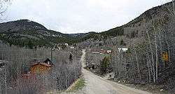 Main street in Garfield | |
 Garfield, Colorado Location within the state of Colorado | |
| Coordinates: 38°33′06″N 106°17′32″W | |
| Country | USA |
| State | |
| Counties | Chaffee |
| Elevation | 9,541 ft (2,908 m) |
| Population (2010) | |
| • Total | 15 |
| Time zone | UTC-7 (MST) |
| • Summer (DST) | UTC-6 (MDT) |
| ZIP code[1] | 81201 |
| GNIS code | 204757 |
Demographics
| Historical population | |||
|---|---|---|---|
| Census | Pop. | %± | |
| 2010 | 15 | — | |
| U.S. Decennial Census[4] | |||
gollark: Or just one RX580.
gollark: You should demand RX580s instead.
gollark: I've got one with a Pentium 4.
gollark: My mum has a laptop with a Core 2 Duo from about 2009. Somehow it is still going.
gollark: <@229624651314233346> Nothing.
See also
- Outline of Colorado
- State of Colorado
- Colorado cities and towns
- Colorado census designated places
- Colorado counties
- Colorado cities and towns
References
- "ZIP Code Lookup". United States Postal Service. December 27, 2006. Archived from the original (JavaScript/HTML) on December 14, 2006. Retrieved December 27, 2006.
- "Garfield". Geographic Names Information System. United States Geological Survey.
- Colorado Trend Report 2: State and Complete Places (Sub-state 2010 Census Data). Missouri Census Data Center. Accessed 2011-02-25.
- "Census of Population and Housing". Census.gov. Retrieved June 4, 2016.
Municipalities and communities of Chaffee County, Colorado, United States | ||
|---|---|---|
| City | 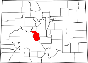 Map of Colorado highlighting Chaffee County | |
| Towns | ||
| CDPs | ||
| Unincorporated communities | ||
This article is issued from Wikipedia. The text is licensed under Creative Commons - Attribution - Sharealike. Additional terms may apply for the media files.