Galva Township, Henry County, Illinois
Galva Township is one of twenty-four townships in Henry County, Illinois, USA. As of the 2010 census, its population was 2,837 and it contained 1,402 housing units.[2]
Galva Township | |
|---|---|
 Location in Henry County | |
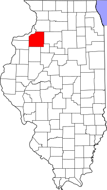
 Henry County's location in Illinois | |
| Coordinates: 41°11′35″N 90°02′25″W | |
| Country | |
| State | |
| County | Henry |
| Established | November 4, 1856 |
| Area | |
| • Total | 34.29 sq mi (88.8 km2) |
| • Land | 34.28 sq mi (88.8 km2) |
| • Water | 0.01 sq mi (0.03 km2) 0.03% |
| Elevation | 761 ft (232 m) |
| Population (2010) | |
| • Estimate (2016)[1] | 2,745 |
| • Density | 82.8/sq mi (32.0/km2) |
| Time zone | UTC-6 (CST) |
| • Summer (DST) | UTC-5 (CDT) |
| ZIP codes | 61238, 61434, 61443 |
| FIPS code | 17-073-28443 |
Geography
According to the 2010 census, the township has a total area of 34.29 square miles (88.8 km2), of which 34.28 square miles (88.8 km2) (or 99.97%) is land and 0.01 square miles (0.026 km2) (or 0.03%) is water.[2]
Cities, towns, villages
Adjacent townships
- Burns Township (north)
- Wethersfield Township (east)
- Goshen Township, Stark County (southeast)
- Lynn Township, Knox County (south)
- Walnut Grove Township, Knox County (southwest)
- Weller Township (west)
- Cambridge Township (northwest)
Cemeteries
The township contains Saint Johns Cemetery.
Major highways
Landmarks
- Wiley Park
School districts
- Galva Community Unit School District 224
- Wethersfield Community Unit School District 230
Political districts
- Illinois's 17th congressional district
- State House District 74
- State Senate District 37
gollark: I'll send you some samples.
gollark: Wow, VSCode is *fine* with editing this 8MB JSON file.
gollark: I forgot the URL.
gollark: ,flappy fly bird man?
gollark: We've lost WEEKS of soul harvesting data to bugginess.
References
- "Galva Township, Henry County, Illinois". Geographic Names Information System. United States Geological Survey. Retrieved 2010-01-17.
- United States Census Bureau 2008 TIGER/Line Shapefiles
- United States National Atlas
- "Population and Housing Unit Estimates". Retrieved June 9, 2017.
- "Population, Housing Units, Area, and Density: 2010 - County -- County Subdivision and Place -- 2010 Census Summary File 1". United States Census. Archived from the original on 2020-02-12. Retrieved 2013-05-28.
- Gannett, Henry (1905). The Origin of Certain Place Names in the United States. Govt. Print. Off. pp. 134.
- "Census of Population and Housing". Census.gov. Retrieved June 4, 2016.
External links
This article is issued from Wikipedia. The text is licensed under Creative Commons - Attribution - Sharealike. Additional terms may apply for the media files.