Galt, Missouri
Galt is a city in Grundy County, Missouri, United States. The population was 253 at the 2010 census.
Galt, Missouri | |
|---|---|
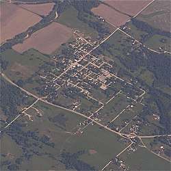 Galt, Missouri seen from the air. | |
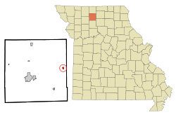 Location of Galt, Missouri | |
| Coordinates: 40°7′38″N 93°23′13″W | |
| Country | United States |
| State | Missouri |
| County | Grundy |
| Area | |
| • Total | 0.29 sq mi (0.74 km2) |
| • Land | 0.29 sq mi (0.74 km2) |
| • Water | 0.00 sq mi (0.00 km2) |
| Elevation | 840 ft (256 m) |
| Population | |
| • Total | 253 |
| • Estimate (2019)[3] | 247 |
| • Density | 863.64/sq mi (333.87/km2) |
| Time zone | UTC-6 (Central (CST)) |
| • Summer (DST) | UTC-5 (CDT) |
| ZIP code | 64641 |
| Area code(s) | 660 |
| FIPS code | 29-26362[4] |
| GNIS feature ID | 0730102[5] |
History
Galt was platted in 1881 when the railroad was extended to that point.[6] A post office called Galt has been in operation since 1881.[7]
Geography
Galt is located at 40°07′38″N 93°23′13″W.[8]
According to the United States Census Bureau, the city has a total area of 0.29 square miles (0.75 km2), all land.[9]
Demographics
| Historical population | |||
|---|---|---|---|
| Census | Pop. | %± | |
| 1890 | 653 | — | |
| 1900 | 582 | −10.9% | |
| 1910 | 583 | 0.2% | |
| 1920 | 587 | 0.7% | |
| 1930 | 467 | −20.4% | |
| 1940 | 525 | 12.4% | |
| 1950 | 409 | −22.1% | |
| 1960 | 373 | −8.8% | |
| 1970 | 261 | −30.0% | |
| 1980 | 323 | 23.8% | |
| 1990 | 296 | −8.4% | |
| 2000 | 275 | −7.1% | |
| 2010 | 253 | −8.0% | |
| Est. 2019 | 247 | [3] | −2.4% |
| U.S. Decennial Census[10] | |||
2010 census
As of the census[2] of 2010, there were 253 people, 109 households, and 70 families residing in the city. The population density was 872.4 inhabitants per square mile (336.8/km2). There were 138 housing units at an average density of 475.9 per square mile (183.7/km2). The racial makeup of the city was 94.9% White, 1.6% African American, 0.4% Native American, 0.4% Asian, 0.4% Pacific Islander, and 2.4% from two or more races.
There were 109 households, of which 30.3% had children under the age of 18 living with them, 44.0% were married couples living together, 13.8% had a female householder with no husband present, 6.4% had a male householder with no wife present, and 35.8% were non-families. 28.4% of all households were made up of individuals, and 11.9% had someone living alone who was 65 years of age or older. The average household size was 2.32 and the average family size was 2.83.
The median age in the city was 39.8 years. 24.1% of residents were under the age of 18; 9.8% were between the ages of 18 and 24; 22.8% were from 25 to 44; 28% were from 45 to 64; and 15% were 65 years of age or older. The gender makeup of the city was 51.4% male and 48.6% female.
2000 census
As of the census[4] of 2000, there were 275 people, 122 households, and 71 families residing in the city. The population density was 957.3 people per square mile (366.1/km2). There were 149 housing units at an average density of 518.7 per square mile (198.4/km2). The racial makeup of the city was 98.55% White 0.36% Native American, and 1.09% from two or more races. Hispanic or Latino of any race were 0.73% of the population.
There were 122 households, out of which 31.1% had children under the age of 18 living with them, 43.4% were married couples living together, 12.3% had a female householder with no husband present, and 41.8% were non-families. 36.9% of all households were made up of individuals, and 18.9% had someone living alone who was 65 years of age or older. The average household size was 2.25 and the average family size was 2.93.
In the city the population was spread out, with 27.3% under the age of 18, 9.5% from 18 to 24, 25.8% from 25 to 44, 21.1% from 45 to 64, and 16.4% who were 65 years of age or older. The median age was 38 years. For every 100 females, there were 83.3 males. For every 100 females age 18 and over, there were 81.8 males.
The median income for a household in the city was $24,375, and the median income for a family was $26,667. Males had a median income of $27,386 versus $17,000 for females. The per capita income for the city was $10,493. About 18.9% of families and 23.7% of the population were below the poverty line, including 37.0% of those under the age of eighteen and 15.4% of those 65 or over.
References
- "2019 U.S. Gazetteer Files". United States Census Bureau. Retrieved July 26, 2020.
- "U.S. Census website". United States Census Bureau. Retrieved 2012-07-08.
- "Population and Housing Unit Estimates". United States Census Bureau. May 24, 2020. Retrieved May 27, 2020.
- "U.S. Census website". United States Census Bureau. Retrieved 2008-01-31.
- "US Board on Geographic Names". United States Geological Survey. 2007-10-25. Retrieved 2008-01-31.
- "Grundy County Place Names, 1928–1945 (archived)". The State Historical Society of Missouri. Archived from the original on 24 June 2016. Retrieved 3 October 2016.CS1 maint: BOT: original-url status unknown (link)
- "Post Offices". Jim Forte Postal History. Archived from the original on 6 October 2014. Retrieved 3 October 2016.
- "US Gazetteer files: 2010, 2000, and 1990". United States Census Bureau. 2011-02-12. Retrieved 2011-04-23.
- "US Gazetteer files 2010". United States Census Bureau. Archived from the original on 2012-07-02. Retrieved 2012-07-08.
- "Census of Population and Housing". Census.gov. Retrieved June 4, 2015.
External links
- Historic maps of Galt in the Sanborn Maps of Missouri Collection at the University of Missouri
Municipalities and communities of Grundy County, Missouri, United States | ||
|---|---|---|
| Cities | 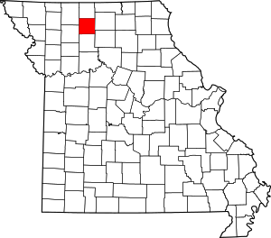 Map of Missouri highlighting Grundy County | |
| Village | ||
| Townships | ||
| CDPs | ||
| Unincorparated communities | ||
| Footnotes | ‡This populated place also has portions in an adjacent county or counties | |