Forest, Virginia
Forest is a census-designated place (CDP) in Bedford and Campbell counties in the U.S. state of Virginia. The population was 9,106 at the 2010 census.[3] It is part of the Lynchburg Metropolitan Statistical Area.
Forest, Virginia | |
|---|---|
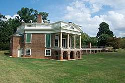 Thomas Jefferson's Poplar Forest | |
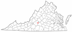 Location of Forest, Virginia | |
| Coordinates: 37°22′15″N 79°16′0″W | |
| Country | United States |
| State | Virginia |
| County | Bedford, Campbell |
| Area | |
| • Total | 13.9 sq mi (35.9 km2) |
| • Land | 13.7 sq mi (35.6 km2) |
| • Water | 0.1 sq mi (0.3 km2) |
| Elevation | 873 ft (266 m) |
| Population (2010) | |
| • Total | 9,106 |
| • Density | 660/sq mi (250/km2) |
| Time zone | UTC−5 (Eastern (EST)) |
| • Summer (DST) | UTC−4 (EDT) |
| ZIP code | 24551 |
| Area code(s) | 434 |
| FIPS code | 51-28688[1] |
| GNIS feature ID | 1494932[2] |
Geography
Forest is located at 37°22′15″N 79°16′0″W (37.370723, −79.266801).[4]
According to the United States Census Bureau, the CDP has a total area of 13.9 square miles (35.9 km2), of which 13.7 square miles (35.6 km2) is land and 0.12 square miles (0.3 km2), or 0.89%, is water.[5]
Community
Forest is a suburban part of metropolitan Lynchburg, containing many subdivided properties carved from and around surrounding farms and woodlands. The Ivy Hill community is the largest development and is built around the Ivy Hill Golf Course. The community has been experiencing rapid growth and development over the past 10 years, especially after Rte 221/Forest Road was widened to 4 lanes in 2009. The growth of commercial businesses and housing which slowed briefly during the 2007-2010 recession, is expected to continue into the near future. The recent construction of shopping centers such as Cavalier Corner and the large Forest Square strip mall beside the post office, along with the addition of several restaurants, evidence this recent growth. Forest is home to Jefferson Forest High School (the Cavaliers, ~1400 students), Forest Middle School (the Knights, ~1100 students), Forest Elementary School, Thomas Jefferson Elementary School, Timberlake Christian School, and New London Academy.
Forest has no real town center since the original one was torn down without a trace, but the area along U.S. Route 221 from the post office to the Forest Library is generally regarded as the central part of the community; however, technically the community extends all the way along Rt. 221 from the middle school to Graves Mill Shopping Center. The political attitudes of the majority of the population are conservative. There are a few older homes along a loop behind the library and two churches that would have been in close proximity to the former N&W rail station, which was torn down in the late 2010s. This might have been considered the main stop for Forest prior to sub-urbanization and commercial development along Rte.221/Forest Road.
Liberty University's Center for Engineering Research and Education (CERE) in the New London Business & Technology Center park on Hwy. 460 in New London is a small but increasingly significant engineering center developed with partnerships by private industry, regional governments, the Tobacco Commission, in addition to the University. Existing businesses in the park include Simplimatic Automation, NanoSeptic Technologies, and a new 40,000 SF shell building is available for sale or lease. With the expansion of Liberty University in the park and water and sewer infrastructure investments by Bedford County, the site is an attractive location for increased development. .
A partnership with a subsidiary of Blue Ridge Towers and Bedford County to increase Broadband access throughout the entire county is also underway. Many residential properties in established neighborhoods in Forest already have access to broadband via cable service providers the county as a whole however is very large in land size and largely rural.
The most popular attraction of the town is Poplar Forest, the summer home of Thomas Jefferson, which is open to the public for visitation and is the subject of ongoing archaeological studies. The home is also used for events. Nearby attractions include Point of Honor in Lynchburg, the National D-Day Memorial in Bedford, and the Peaks of Otter in the Blue Ridge Mountains. The nearest urban center is downtown Lynchburg, approximately 10 miles (16 km) northeast of town. Forest is accessed via Route 221 and U.S. Route 460. The nearest rail line is Amtrak's Crescent train at the Kemper Street station in Lynchburg. Amtrak Virginia also provides regional service with a Lynchburg stop between Roanoke and Northern VA/Washington, D.C. The nearest major airport is Lynchburg Regional Airport offering commercial service through US Airways Express to Charlotte, North Carolina. Private charter flights are available through Virginia Aviation. There is also a public general aviation (GA) airport, New London Airport, which is open for all GA pilots.
Demographics
As of the census[1] of 2000, there were 8,006 people, 3,172 households, and 2,293 families residing in the CDP. The population density was 547.8 people per square mile (211.6/km2). There were 3,294 housing units at an average density of 225.4/sq mi (87.1/km2). The racial makeup of the CDP was 91.79% White, 5.65% African American, 0.10% Native American, 1.36% Asian, 0.01% Pacific Islander, 0.27% from other races, and 0.81% from two or more races. Hispanic or Latino of any race were 0.95% of the population.
There were 3,172 households, out of which 35.8% had children under the age of 18 living with them, 62.9% were married couples living together, 7.2% had a female householder with no husband present, and 27.7% were non-families. 24.5% of all households were made up of individuals, and 5.8% had someone living alone who was 65 years of age or older. The average household size was 2.52 and the average family size was 3.03.
In the CDP the population was spread out, with 26.9% under the age of 18, 6.1% from 18 to 24, 31.5% from 25 to 44, 26.0% from 45 to 64, and 9.5% who were 65 years of age or older. The median age was 38 years. For every 100 females there were 96.8 males. For every 100 females age 18 and over, there were 92.6 males.
The median income for a household in the CDP was $55,089, and the median income for a family was $67,055. Males had a median income of $46,057 versus $30,720 for females. The per capita income for the CDP was $25,735. About 2.9% of families and 3.1% of the population were below the poverty line, including 1.3% of those under age 18 and 3.7% of those age 65 or over.
Notable people
- Cynthia Dunbar, Republican National Committeewoman for Virginia; law professor at Liberty University School of Law, former member of the Texas State Board of Education.[6]
- Rashad Jennings, NFL running back formerly for the New York Giants, the Oakland Raiders, and the Jacksonville Jaguars[7]
References
- "U.S. Census website". United States Census Bureau. Retrieved 2008-01-31.
- "US Board on Geographic Names". United States Geological Survey. 2007-10-25. Retrieved 2008-01-31.
- "Profile of General Population and Housing Characteristics: 2010 Demographic Profile Data (DP-1): Forest CDP, Virginia". United States Census Bureau. Retrieved February 14, 2012.
- "US Gazetteer files: 2010, 2000, and 1990". United States Census Bureau. 2011-02-12. Retrieved 2011-04-23.
- "Geographic Identifiers: 2010 Demographic Profile Data (G001): Forest CDP, Virginia". United States Census Bureau. Retrieved February 14, 2012.
- "Cruz-campaign-leader-rails-against-socialized-education-system-and-homosexualitys-prevention". People for the American Way. September 7, 2016. Archived from the original on December 29, 2016. Retrieved December 28, 2016.
- http://www.liberty.edu/flames/index.cfm?PID=10872&RosterID=1155&TeamID=9
External links
Municipalities and communities of Bedford County, Virginia, United States | ||
|---|---|---|
| Town | 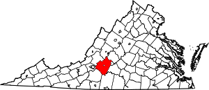 Map of Virginia highlighting Bedford County | |
| CDPs | ||
| Unincorporated communities |
| |
Municipalities and communities of Campbell County, Virginia, United States | ||
|---|---|---|
| Towns | 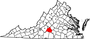 Map of Virginia highlighting Campbell County | |
| CDPs | ||
| Unincorporated communities | ||
| Footnotes | ‡This populated place also has portions in an adjacent county or counties | |