February 1995 nor'easter
The February 1995 Northeast United States snowstorm was a significant nor'easter that impacted the Mid-Atlantic and New England regions of the United States around the beginning of the month.[1] It was the only major nor'easter of the 1994–1995 winter.[2]
Category 2 "Significant" (RSI: 4.28) | |
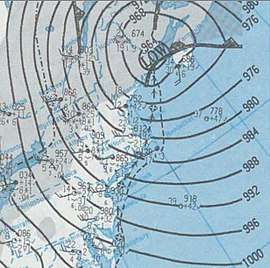
 A surface weather analysis of the nor'easter | |
| Type | Nor'easter |
|---|---|
| Formed | February 2, 1995 |
| Dissipated | February 6, 1995 |
| Lowest pressure | 962 mbar (28.4 inHg) |
| Highest winds |
|
Synoptic history

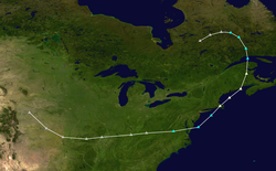
The initial low pressure area tracked eastward from the southern Great Plains on February 2. Gradually intensifying, it was situated over eastern Kentucky by 0000 UTC on February 4. As the system entered West Virginia, a secondary low began to develop over South Carolina. The new low quickly deepened, and absorbed the primary low over West Virginia into its expanding and strengthening circulation. It continued to rapidly mature as it moved northward from eastern Maryland,[2] and it hugged the coast as it moved northeastward towards southern New England.[3]
The cyclone reached a strength of 980 millibars while located south of Long Island. It crossed eastern New England and reached its peak intensity, with a minimum barometric pressure of 962 mb and sustained winds of 75 mph (120 km/h), over eastern Maine.[4] Prior to the nor'easter, an area of high pressure drifted southeastward from north of the Great Lakes, producing sufficient cold air to support snow throughout the Northeast. However, as the storm intensified, precipitation near the coast, including the major cities of Philadelphia, New York, and Boston, changed to rain. Due to the lack of a strong anticyclone at the surface, winds in association with the system were minimal until after the storm abated.[2] Behind the nor'easter, high winds, sufficient to bring down trees and powerlines, occurred.[5]
Impact
Snow from the nor'easter was heavy and widespread. Areas that picked up 10 in (250 mm) or more include Pennsylvania, New York, New Jersey, Connecticut, Massachusetts, Vermont, New Hampshire and Maine. Scattered reports of 20 in (510 mm) were received in upstate New York and northern Vermont.[2] At Burlington, Vermont, 16.8 in (430 mm) of snow fell, beating the daily record of 8.7 in (220 mm) set in 1988.[6] Overall, the event ranks as a category 2 on the Northeast Snowfall Impact Scale.[2]
In Pennsylvania, the heaviest snow fell in Bucks County. Throughout the state, the number of traffic accidents was minimized due to the storm's arrival on a weekend. Three died of cardiac arrest after shoveling snow, and more than 100 people were hospitalized for chest pain. Several dozen more were injured after slipping and falling on ice, and 53 residents sustained snowblower-related injuries.[7] At least 18 people were injured in nearby New Jersey, where the maximum snow accumulation was reported to be 16 inches (41 cm) in Princeton.[8] Along the coast, minor to moderate coastal flooding occurred, along with some beach erosion. Some areas lost power for several hours as fallen tree branches downed power lines.[9] The cyclone also produced heavy snow and coastal flooding in New York.[10]
See also
- Climate of the United States
- List of NESIS storms
References
- "Rank: 10 | 5 February 1995 | Score: 134.15". Lyndon State College. Retrieved January 6, 2010.
- Kocin and Uccellini, p. 590
- "February 04–6 Observed Liquid Precipitation". Lyndon State College. Retrieved January 6, 2010.
- Atlantic High Seas Forecast February 5, 1995 (Report). Iowa Environmental Mesonet. National Weather Service Weather NMC. February 5, 1995. Retrieved June 5, 2020.
- "Event Record Details for New York: High Winds". National Climatic Data Center. Retrieved January 5, 2010.
- "Event Record Details for Vermont: Heavy Snow". National Climatic Data Center. Retrieved January 5, 2010.
- "Event Record Details for Pennsylvania: Heavy Snow". National Climatic Data Center. Retrieved January 5, 2010.
- "Event Record Details for New Jersey: Heavy Snow". National Climatic Data Center. Retrieved January 5, 2010.
- "Event Record Details for New Jersey: Coastal Flooding". National Climatic Data Center. Retrieved January 5, 2010.
- "Event Record Details for New York: Coastal Flooding". National Climatic Data Center. Retrieved January 5, 2010.
- Paul J. Kocin and Louis W. Uccellini (2004). Northeast Snowstorms. American Meteorological Society. ISBN 1-878220-64-0.