Regional Snowfall Index
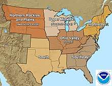
The regional snowfall index (RSI) is a system used by NOAA to assess the societal impact of winter storms in the six easternmost regions of the United States. The system was implemented in 2014, and is a replacement for the Northeast Snowfall Impact Scale (NESIS) system which the National Climatic Data Center (NCDC) began using in 2005. The NCDC has retroactively assigned RSI values to almost 600 historical storms since 1900.[1]
| Category | RSI value | Description |
|---|---|---|
| 1 | 1–3 | Notable |
| 2 | 3–6 | Significant |
| 3 | 6–10 | Major |
| 4 | 10–18 | Crippling |
| 5 | 18.0+ | Extreme |
The index makes use of population and regional differences to assess the impact of snowfall. For example, areas which receive very little snowfall on average may be more adversely affected than other regions, and so the index will grant storms in those regions higher severity.[2]
Overview

In each region, four "thresholds" are set based on climatological records:
- one quarter of the amount of snow typically occurring once every 10 years
- one half of the amount of snow typically occurring once every 25 years
- the amount of snow typically occurring once every 25 years
- one and a half times the amount of snow typically occurring once every 25 years
For example, in the Northeast, a typical location will get 16 inches of snow about once every 10 years and 20 inches about once every 25, so the thresholds are 4, 10, 20, and 30 inches.
For each threshold and each region, a baseline area and population are determined; for a given storm, the area that exceeds a particular threshold will be normalized by the baseline value. For example, for a storm in the northeast, the area receiving at least 4 inches of snow is divided by 149,228 square miles, and the population affected is divided by 51,553,600 (using 2010 census data). This gives eight different numbers representing how widespread the storm is compared to notable snow storms in that region. The baseline area and population represent the average area and population for large storms, so that each of these eight different measures will average 1 among storms considered notable (for the calibration sample). The RSI is simply the total of these eight numbers.
References
- Squires, Michael F.; Lawrimore, Jay H.; Heim Jr., Richard R.; Robinson, David A.; Gerbush, Mathieu R.; Estilow, Thomas W. (December 2014). "The Regional Snowfall Index". Bulletin of the American Meteorological Society. American Meteorological Society. 95 (12): 1835–1848. doi:10.1175/BAMS-D-13-00101.1. ISSN 0003-0007 – via EBSCOhost Applied Science & Technology Source.
- Furgurson III, E.B. (January 29, 2016). "Snowstorm was Category 4 on NOAA winter storm scale". The Capital. Retrieved 3 March 2019 – via EBSCOhost Newspaper Source Plus.