Fanteakwa District
The Fanteakwa District is one of the twenty-one (21) districts of the Eastern Region of south Ghana. The capital is Begoro.[1]
Fanteakwa District | |
|---|---|
District | |
Seal | |
 Eastern Region districts | |
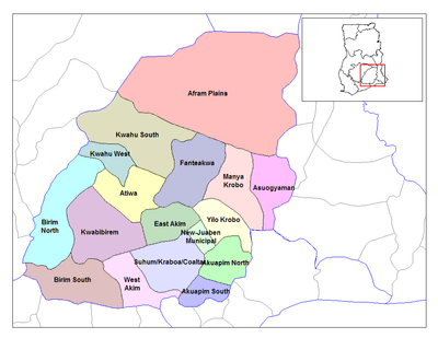
 Fanteakwa District Location of Fanteakwa district in Eastern Region | |
| Coordinates: 6.3842°N 0.3833°W | |
| Region | Eastern Region |
| Capital | Begoro |
| Government | |
| • Type | District Assembly |
| • District Executive | Ofoe Caesar |
| Area | |
| • Total | 1,066 km2 (412 sq mi) |
| Time zone | UTC+0 (Greenwich Mean Time) |
| • Summer (DST) | GMT |
List of settlements
| Settlements of Fanteakwa District | |||
| No. | Settlement | Population | Population year |
|---|---|---|---|
| 1 | Abompe | ||
| 2 | Adjeiikrom | ||
| 3 | Akwadum Dorse | ||
| 4 | Ahoniahoniaso | ||
| 5 | Akyem Hemang | ||
| 6 | Ayiensu | ||
| 7 | Begoro | 29,516 | 2013 |
| 8 | Bepoase | ||
| 9 | Bososo | ||
| 10 | Bisibom | ||
| 11 | Dedesoworako | ||
| 12 | Dwenase | ||
| 13 | Ehiamankyene-Odumase | ||
| 14 | Juaso | ||
| 15 | Nsutam | ||
| 16 | Nteso No. 1 (Amokrom) | ||
| 17 | Obooho | ||
| 18 | Osino | ||
| 19 | Saaman | ||
| 20 | Summer | ||
gollark: `(int)beeoid`
gollark: Okay, looks like sum can be fixed.
gollark: Troubling.
gollark: Technically, ctypes has arrays.
gollark: Is it? I assumed it just implicitly added a `0` of some sort.
References
- Fanteakwa district Archived 2013-10-29 at the Wayback Machine
Sources
External links
| Municipal |
| .svg.png) |
|---|---|---|
| District |
| |
This article is issued from Wikipedia. The text is licensed under Creative Commons - Attribution - Sharealike. Additional terms may apply for the media files.