Extreme wind warning
An extreme wind warning (SAME code EWW) is an alert issued by the National Weather Service for areas that are experiencing or could experience 100 knots (115 mph, 185 km/h, 51 m/s) within an hour due to non-convective, downslope, derecho, or sustained hurricane winds are expected to occur within one hour.[1] EWWs are intended to provide guidance to the general public at a county or sub-county level of winds that could pose a significant threat of casualties. Their issuance is intended to cover as precise of an area as possible and can be issued no prior than two hours before the onset of extreme winds.[2]
The motivation to create a short-fused warning for extreme winds began after Hurricane Charley and Hurricane Jeanne struck Florida in 2004. During the passage of Charley across the state, strong winds prompted the National Weather Service weather forecast office in Melbourne, Florida to issue a special bulletin advising immediate action due to the onset of life-threatening winds by embedding the bulletin within a tornado warning, thus giving the bulletin higher visibility and urgency. The forecast office also issued similar "tornado" warnings as the strong winds of Jeanne moved ashore from the east later that year.[3] The nonconventional usage of tornado warnings for extreme hurricane winds was praised by emergency management, citing it as an ingenious method of protecting lives.[4] In December 2004, the Melbourne forecast office briefed attendees at an annual NOAA Hurricane Conference on their use of the special tornado warning, advocating and eventually reaching consensus for a specialized official National Weather Service product for extreme winds.[3]
The new warning was standardized in its experimental stages in 2005, so weather forecast offices continued to use special tornado warnings to broadcast the threat of severe wind during the landfalls of Hurricanes Dennis, Katrina, Rita, and Wilma. The wind and temporal thresholds that eventually became a part of extreme wind warnings were also used as thresholds for these special tornado warnings in 2005.[2] The warnings, termed Extreme Tropical Cyclone Destructive Wind Warnings, advised residents to take sturdy shelter in the interior portions of well-built structures. During Katrina, the weather services serving the Jackson and New Orleans and Baton Rouge, Louisiana issued 19 warnings. Public response to these warnings was mixed, praising their specificity but finding their placement within tornado warnings confusing, particularly when they were issued near traditional tornado warnings. The advice of taking interior low-level shelter given in the wind warnings also contradicted the advice given in Hurricane Local Statements of taking interior shelter in elevated floors for storm surge-prone areas. NOAA/NWS recommendations called for the development of an extreme wind warning independent from tornado warnings and increased outreach for the warning.[4]
The following year, extreme wind warnings continued to be packaged within special tornado warnings for public evaluation,[5] and the warning became its own official independent product by the 2007 Atlantic hurricane season,[6] though no hurricane would trigger an extreme wind warning for nearly another decade. Despite the newly independent warning system, until the 2015 Atlantic hurricane season, the Emergency Alert System continued to broadcast EWWs as tornado warnings (using the TOR event code).[4] On the morning of October 7, 2016, the nearby passage of Category 3 Hurricane Matthew just off of Cape Canaveral prompted the first issuance of an extreme wind warning.[7]
Issuances
| Date | State / Territory | Locations | Event | Weather Forecast Office | Warning Text |
|---|---|---|---|---|---|
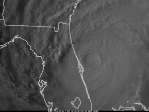
| October 7, 2016 | Florida | Brevard | Hurricane Matthew | MLB (Melbourne, FL) | Extreme Wind Warning #1 - National Weather Service - Melbourne, FL BULLETIN - EAS ACTIVATION REQUESTED EXTREME WIND WARNING NATIONAL WEATHER SERVICE MELBOURNE FL 526 AM EDT FRI OCT 7 2016 THE NATIONAL WEATHER SERVICE IN MELBOURNE HAS ISSUED A * EXTREME WIND WARNING FOR... NORTHEASTERN BREVARD COUNTY IN FLORIDA... * UNTIL 715 AM EDT * AT 521 AM EDT...SURFACE OBSERVATIONS AND DOPPLER RADAR INDICATED EXTREME WINDS... ASSOCIATED WITH THE EYEWALL OF HURRICANE MATTHEW WERE ABOUT TO MOVE ONSHORE CAPE CANAVERAL INCLUDING PORT CANAVERAL AND MOVING NORTH-NORTHWEST AT 15 MPH. THIS IS AN EXTREMELY DANGEROUS AND LIFE-THREATENING SITUATION! PRECAUTIONARY/PREPAREDNESS ACTIONS... FREQUENT DESTRUCTIVE WIND GUSTS TO AROUND 115 MPH WILL SPREAD ACROSS THE CAPE CANAVERAL AREA...PRODUCING SWATHS OF TORNADO-LIKE DAMAGE. A WIND GUST OF 100 MPH WAS RECENTLY RECORDED AT THE TIP OF CAPE CANAVERAL. |
| August 25, 2017 | Texas | Aransas, Calhoun, Nueces, San Patricio, Refugio | Hurricane Harvey | CRP (Corpus Christi, TX) | Extreme Wind Warning #2 - National Weather Service - Corpus Christi, TX BULLETIN - EAS ACTIVATION REQUESTED Extreme Wind Warning National Weather Service Corpus Christi TX 456 PM CDT FRI AUG 25 2017 The National Weather Service in Corpus Christi has issued a * Extreme Wind Warning for... Southwestern Calhoun County in south Texas... Aransas County in south central Texas... East central Nueces County in south central Texas... Eastern San Patricio County in south central Texas... Central Refugio County in south central Texas... * Until 700 PM CDT * At 454 PM CDT, National Weather Service Doppler radar indicated extreme winds, associated with the eyewall of Hurricane Harvey, were moving onshore 17 miles east of Key Allegro, or 18 miles east of Rockport, moving northwest at 25 mph. This is an extremely dangerous and life-threatening situation! PRECAUTIONARY/PREPAREDNESS ACTIONS... Widespread destructive winds of 115 to 145 mph will spread across Calhoun County, Aransas County, Nueces County, San Patricio County, Refugio County, producing swaths of tornado-like damage. TAKE COVER NOW! Treat these imminent extreme winds as if a tornado was approaching and move immediately to the safe room in your shelter. Take action now to protect your life! |
| September 6, 2017 | U.S. Virgin Islands | Saint John, Saint Thomas | Hurricane Irma | SJU (San Juan, PR) | Extreme Wind Warning #3 - National Weather Service - San Juan, PR BULLETIN - EAS ACTIVATION REQUESTED Extreme Wind Warning National Weather Service San Juan PR 1116 AM AST WED SEP 6 2017 The National Weather Service in San Juan has issued a * Extreme Wind Warning for... Saint John in Virgin Islands... Saint Thomas in Virgin Islands... * Until 115 PM AST * At 1114 AM AST, National Weather Service Doppler radar indicated extreme winds, associated with the eyewall of Major Hurricane Irma, about to move over St John, moving west at 20 mph. This extreme winds will affect St John and St Thomas through 100 PM AST. This is an extremely dangerous and life-threatening situation! PRECAUTIONARY/PREPAREDNESS ACTIONS... TAKE COVER NOW! Treat these imminent extreme winds as if a tornado was approaching and move immediately to the safe room in your shelter. Take action now to protect your life! The safest place to be during a major landfalling hurricane is in a reinforced interior room away from windows. Get under a table or other piece of sturdy furniture. Use mattresses, blankets or pillows to cover your head and body. Remain in place through the passage of these life-threatening conditions. |
| September 10, 2017 | Florida | Collier | Hurricane Irma | MFL (Miami, FL) | Extreme Wind Warning #4 - National Weather Service - Miami, FL BULLETIN - EAS ACTIVATION REQUESTED Extreme Wind Warning National Weather Service Miami FL 1225 PM EDT SUN SEP 10 2017 The National Weather Service in Miami has issued a * Extreme Wind Warning for... Southwestern Collier County in southwestern Florida... * Until 330 PM EDT * At 1223 PM EDT, National Weather Service Doppler radar indicated extreme winds above 115 mph, associated with the eyewall of Hurricane Irma, were approaching the coast 10 miles south of Everglades City, moving north at 15 mph. This is an extremely dangerous and life-threatening situation! * Locations impacted include... Naples, Marco Island, Chokoloskee, Golden Gate Estates and Everglades City. PRECAUTIONARY/PREPAREDNESS ACTIONS... The safest place to be during a major landfalling hurricane is in a reinforced interior room away from windows. Get under a table or other piece of sturdy furniture. Use mattresses, blankets or pillows to cover your head and body. Remain in place through the passage of these life-threatening conditions. |
| September 10, 2017 | Florida | Collier, Hendry | Hurricane Irma | MFL (Miami, FL) | Extreme Wind Warning #5 - National Weather Service - Miami, FL BULLETIN - EAS ACTIVATION REQUESTED Extreme Wind Warning National Weather Service Miami FL 327 PM EDT SUN SEP 10 2017 The National Weather Service in Miami has issued a * Extreme Wind Warning for... Western Collier County in southwestern Florida... West central Hendry County in southern Florida... * Until 530 PM EDT * At 326 PM EDT, surface observations indicated extreme winds of over 120 mph, associated with the eyewall of Hurricane Irma, were moving onshore over Marco Island, or near Naples, moving north at 15 mph. This is an extremely dangerous and life-threatening situation! * Locations impacted include... Naples, Marco Island, Chokoloskee, Ave Maria and Golden Gate Estates. PRECAUTIONARY/PREPAREDNESS ACTIONS... TAKE COVER NOW! Treat these imminent extreme winds as if a tornado was approaching and move immediately to the safe room in your shelter. Take action now to protect your life! The safest place to be during a major landfalling hurricane is in a reinforced interior room away from windows. Get under a table or other piece of sturdy furniture. Use mattresses, blankets or pillows to cover your head and body. Remain in place through the passage of these life-threatening conditions. |
| September 10, 2017 | Florida | Lee | Hurricane Irma | TBW (Tampa Bay Area-Ruskin, FL) | Extreme Wind Warning #6 - National Weather Service - Tampa Bay Area, FL BULLETIN - EAS ACTIVATION REQUESTED Extreme Wind Warning National Weather Service Tampa Bay Area Ruskin FL 405 PM EDT SUN SEP 10 2017 The National Weather Service in Ruskin has issued a * Extreme Wind Warning for... Lee County in southwestern Florida... * Until 600 PM EDT * At 403 PM EDT, National Weather Service Doppler radar and surface observations indicated extreme winds, associated with the eyewall of Hurricane Irma, were moving onshore over Vineyards, or 5 miles northeast of Naples, moving north at 10 mph. This is an extremely dangerous and life-threatening situation! * Extreme winds will be near... Bonita Springs around 430 PM EDT. Lovers Key State Park around 500 PM EDT. Three Oaks and San Carlos Park around 530 PM EDT. Southwest Florida Airport around 540 PM EDT. Villas, East Dunbar, Pine Manor and Cypress Lake around 550 PM EDT. Other locations impacted by extreme winds include Saint James City, Tice, Whiskey Creek, Fort Myers Shores, Page Park, Estero, Page Field Airport, Gateway, Punta Rassa and Alva. PRECAUTIONARY/PREPAREDNESS ACTIONS... TAKE COVER NOW! Treat these imminent extreme winds as if a tornado was approaching and move immediately to the safe room in your shelter. Take action now to protect your life! The safest place to be during a major landfalling hurricane is in a reinforced interior room away from windows. Get under a table or other piece of sturdy furniture. Use mattresses, blankets or pillows to cover your head and body. Remain in place through the passage of these life-threatening conditions. |
| September 20, 2017 | Puerto Rico | Aguas Buenas, Bayamón, Canóvanas, Carolina, Cidra, Guaynabo, Río Grande, San Juan, Trujillo Alto | Hurricane Maria | SJU (San Juan, PR) | Extreme Wind Warning #7 - National Weather Service - San Juan, PR BULLETIN - EAS ACTIVATION REQUESTED Extreme Wind Warning National Weather Service San Juan PR 538 AM AST WED SEP 20 2017 The National Weather Service in San Juan has issued a * Extreme Wind Warning for... Trujillo Alto Municipality in Puerto Rico... Rio Grande Municipality in Puerto Rico... San Juan Municipality in Puerto Rico... Aguas Buenas Municipality in Puerto Rico... Carolina Municipality in Puerto Rico... Canovanas Municipality in Puerto Rico... Guaynabo Municipality in Puerto Rico... Bayamon Municipality in Puerto Rico... Cidra Municipality in Puerto Rico... * Until 700 AM AST * At 533 AM AST, National Weather Service Doppler radar indicated extreme winds, associated with the eyewall of Major Hurricane Maria already moving onshore and will quickly impact Rio Grande, Canovanas, Aguas Buenas, Cidra and the San Juan Metro Area within the next hour. This is an extremely dangerous and life-threatening situation! PRECAUTIONARY/PREPAREDNESS ACTIONS... TAKE COVER NOW! Move immediately to the safe room in your shelter. Take action now to protect your life! The safest place to be during a major landfalling hurricane is in a reinforced interior room away from windows. Get under a table or other piece of sturdy furniture. Use mattresses, blankets or pillows to cover your head and body. Remain in place through the passage of these life-threatening conditions. |
| October 10, 2018 | Florida | Bay, Franklin, Gulf | Hurricane Michael | TLH (Tallahassee, FL) | Extreme Wind Warning #8 - National Weather Service - Tallahassee, FL BULLETIN - EAS ACTIVATION REQUESTED Extreme Wind Warning National Weather Service Tallahassee FL 1111 AM EDT WED OCT 10 2018 The National Weather Service in Tallahassee has issued a * Extreme Wind Warning for... Gulf County in the Panhandle of Florida... Southern Bay County in the Panhandle of Florida... Southwestern Franklin County in Big Bend of Florida... * Until 215 PM EDT/115 PM CDT/. * At 1109 AM EDT/1009 AM CDT/, National Weather Service Doppler radar indicated extreme winds in excess of 130 mph, associated with the eyewall of Hurricane Michael, were moving onshore. THIS IS AN EXTREMELY DANGEROUS AND LIFE-THREATENING SITUATION! PRECAUTIONARY/PREPAREDNESS ACTIONS... TAKE COVER NOW! Treat these imminent extreme winds as if a tornado was approaching and move immediately to the safe room in your shelter. Take action now to protect your life! |
References
- Weather Forecast Office Baltimore/Washington. "Watch/Warning/Advisory Definitions". Sterling, Virginia: National Weather Service. Retrieved October 16, 2018.
- "Extreme Wind Warning (EWW)" (PDF). National Weather Service. Retrieved October 17, 2018.
- Spratt, Scott M.; Hagemeyer, Bartlett C.; Jacobs, David L. (2006). Providing Short-Fused Warnings for the Onset of Extreme Hurricane Winds—A Final Opportunity to Minimize Casualties (PDF). NWS Forecast Office Melbourne, Florida (Report). Melbourne, Florida: National Weather Service. Retrieved October 17, 2018.
- Schott, Timothy. "Request for a new Event Code for the Extreme Wind Warning in Part 11 rules, Subpart B, Section 11.31(e)" (PDF). Federal Communications Commission. Retrieved October 17, 2018.
- Pierce, Therese Z. (May 10, 2006). "Soliciting Comments by November 15, 2006 for Tropical Cyclone Extreme Wind Warning Product" (TXT). Washington, DC: National Weather Service. Retrieved October 17, 2018.
- Hagemeyer, Bartlett C. (January 14, 2009). The extreme wind warning and its role in improving public preparation and response to extreme landfalling hurricane winds in the urban environment. Symposium on Urban High Impact Weather. Phoenix, Arionza: The Conference Exchange.
- Dildine, Dave (October 6, 2016). "Hurricane Matthew could prompt new weather warning for first time". Washington, D.C.: WTOP. Retrieved October 17, 2018.
![]()