Extreme points of Uruguay
This is a list of the extreme points of Uruguay, the points that are farther north, south, east or west than any other location, and the highest and lowest points. It is also notable that Uruguay's northernmost point is farther south than the northernmost point of any other nation.
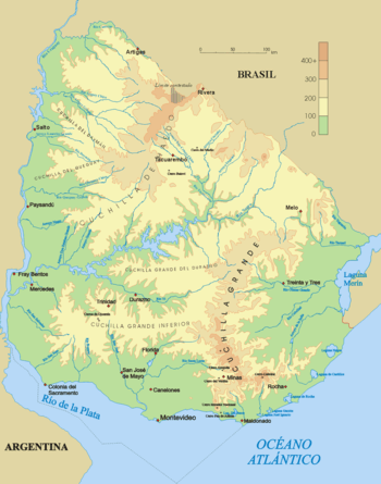
Physical map of Uruguay.
Latitude and longitude
- Northernmost point: Northernmost point of Artigas Department: 30°05′08″S 56°57′06″W
- Southernmost point: Isla de Lobos: 35.031°S 54.884°W
- Southernmost point (mainland): Punta del Este, Maldonado Department: 34.973°S 54.951°W
- Westernmost point: Punta Arenal Grande, San Salvador River, Soriano Department: 33°41′00″S 58°26′21″W
- Easternmost point: mouths of the Yaguarón River at the Laguna Merín, Cerro Largo Department: 32°39′14″S 53°10′58″W
Altitude
- Highest point: Cerro Catedral, Sierra Carapé, Maldonado Department, 514 m
- Lowest point: the coast at sea level.
| History |
|  | |||||||||
|---|---|---|---|---|---|---|---|---|---|---|---|
| Geography | |||||||||||
| Politics |
| ||||||||||
| Economy |
| ||||||||||
| Society |
| ||||||||||
| |||||||||||
gollark: I actually know a nonzero amount about distributed processing tools so I can write about that.
gollark: Oh, that IS a very good image actually.
gollark: I can't find any images beyond random generic "cloud computery" things.
gollark: I'm actually not very sure what to say to say a sufficient amount about the first slide now.
gollark: You make a "draft" and you "improve" the "draft".
This article is issued from Wikipedia. The text is licensed under Creative Commons - Attribution - Sharealike. Additional terms may apply for the media files.