Escuminac, Quebec
Escuminac is a municipality in Quebec, Canada, on the north shore of the Restigouche River.
Escuminac | |
|---|---|
Municipality | |
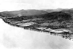 Village of Pointe-à-la-Garde in 1927 | |
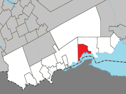 Location within Avignon RCM | |
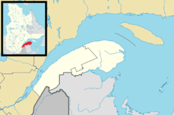 Escuminac Location in eastern Quebec | |
| Coordinates: 48°07′N 66°29′W[1] | |
| Country | |
| Province | |
| Region | Gaspésie– Îles-de-la-Madeleine |
| RCM | Avignon |
| Settled | 2nd half of 18th century |
| Constituted | October 10, 1907 |
| Government | |
| • Mayor | R. Bruce Wafer |
| • Federal riding | Gaspésie— Îles-de-la-Madeleine |
| • Prov. riding | Bonaventure |
| Area | |
| • Total | 107.50 km2 (41.51 sq mi) |
| • Land | 108.43 km2 (41.87 sq mi) |
| There is an apparent contradiction between two authoritative sources | |
| Population (2011)[3] | |
| • Total | 588 |
| • Density | 5.4/km2 (14/sq mi) |
| • Pop 2006-2011 | |
| • Dwellings | 326 |
| Time zone | UTC−5 (EST) |
| • Summer (DST) | UTC−4 (EDT) |
| Postal code(s) | G0C 2M0 |
| Area code(s) | 418 and 581 |
| Highways | |
In addition to Escuminac itself, the municipality also includes the communities of Escuminac Flats, Fleurant, and Pointe-à-la-Garde.
According to missionary Joseph-Étienne Guinard, Escuminac is a Mi'kmaq word meaning "here are small fruits", originally identifying a point of land jutting into the Restigouche River. But this translation has been disputed as fanciful. It has been spelled in various ways over time, including Semenac, Scamanac, Scaumenac, Escouminac, Scoumenac, and Scouminac.[1]
History
The area was first colonized by American Loyalist farmers and loggers.[1]
In 1845, the Municipality of Shoolbred, which included the area now known as Nouvelle, was first incorporated. It was named after John Shoolbred, who was the first owner of the seignory granted there. In 1847, the municipality was abolished but re-established in 1855. From 1861 on, it was known as the Township Municipality of Nouvelle-et-Shoolbred.[4]
In 1907, the township municipality was split into the Municipalities of Nouvelle-et-Shoolbred-Partie-Nord-Est (that became Nouvelle in 1953) and Nouvelle-et-Shoolbred-Partie-Sud-Ouest. This latter one was renamed to Escuminac in 1912.[1]
Demographics
Population
| Canada census – Escuminac, Quebec community profile | |||
|---|---|---|---|
| 2011 | 2006 | ||
| Population: | 588 (-8.8% from 2006) | 645 (+6.8% from 2001) | |
| Land area: | 108.43 km2 (41.87 sq mi) | 108.43 km2 (41.87 sq mi) | |
| Population density: | 5.4/km2 (14/sq mi) | 5.9/km2 (15/sq mi) | |
| Median age: | 46.1 (M: 45.7, F: 46.6) | 44.1 (M: 44.9, F: 43.4) | |
| Total private dwellings: | 326 | 382 | |
| Median household income: | $.N/A | $34,201 | |
| Notes: 2011 income data for this area has been suppressed for data quality or confidentiality reasons. – References: 2011[3] 2006[5] earlier[6] | |||
| Year | Pop. | ±% |
|---|---|---|
| 1991 | 632 | — |
| 1996 | 661 | +4.6% |
| 2001 | 604 | −8.6% |
| 2006 | 645 | +6.8% |
| 2011 | 588 | −8.8% |
Language
Mother tongue:[8]
- English as first language: 38.6%
- French as first language: 61.4%
- English and French as first language: 0%
- Other as first language: 0%
References
- "Escuminac (Municipalité)" (in French). Commission de toponymie du Québec. Retrieved 2012-01-04.
- "Escuminac". Répertoire des municipalités (in French). Ministère des Affaires municipales, des Régions et de l'Occupation du territoire. Archived from the original on 2012-06-10. Retrieved 2012-01-04.
- "2011 Community Profiles". 2011 Canadian Census. Statistics Canada. July 5, 2013. Retrieved 2014-02-06.
- "Nouvelle (Municipalité)" (in French). Commission de toponymie du Québec. Retrieved 2012-01-04.
- "2006 Community Profiles". 2006 Canadian Census. Statistics Canada. March 30, 2011. Retrieved 2012-01-04.
- "2001 Community Profiles". 2001 Canadian Census. Statistics Canada. February 17, 2012.
- Statistics Canada: 1996, 2001, 2006, 2011 census
- "Escuminac community profile". 2006 Census data. Statistics Canada. Retrieved 2012-01-04.
Adjacent Municipal Subdivisions | |
|---|---|
| Cities & Towns | |
|---|---|
| Municipalities |
|
| Townships | |
| Unorganized Territories | |
| |