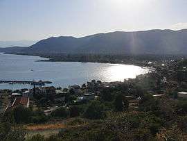
Erateini
Eratini (Greek: Ερατεινή) is a village in the southern part of Phocis, Greece. It was the municipal seat of the municipality of Tolofon. Eratini is situated on the Gulf of Corinth, 14 km west of Galaxidi, 19 km south of Lidoriki, 23 km southwest of Amfissa and 35 km east of Nafpaktos. The Greek National Road 48 (Antirrio - Nafpaktos - Delphi - Livadeia) passes through the village. In 2011, Erateini had a population of 856.
Eratini Ερατεινή | |
|---|---|
 | |
 Eratini | |
| Coordinates: 38°22′N 22°14′E | |
| Country | Greece |
| Administrative region | Central Greece |
| Regional unit | Phocis |
| Municipality | Dorida |
| Municipal unit | Tolofon |
| Community | |
| • Population | 856 (2011) |
| Time zone | UTC+2 (EET) |
| • Summer (DST) | UTC+3 (EEST) |
| Vehicle registration | ΑΜ |
Population
| Year | Population |
|---|---|
| 1981 | 529 |
| 1991 | 572 |
| 2001 | 726 |
| 2011 | 856 |
gollark: And the ability to actually add other FS types (FUSE).
gollark: Oh, and sensible filesystems, that's good.
gollark: With the package manager thing.
gollark: Oh, yes, and convenient updates too.
gollark: Yes, the same awful thing.
External links
See also
References
- "Απογραφή Πληθυσμού - Κατοικιών 2011. ΜΟΝΙΜΟΣ Πληθυσμός" (in Greek). Hellenic Statistical Authority.
This article is issued from Wikipedia. The text is licensed under Creative Commons - Attribution - Sharealike. Additional terms may apply for the media files.