Entrelacs, Quebec
Entrelacs is a municipality in Matawinie Regional County Municipality in the Lanaudière region of Quebec, Canada.
Entrelacs | |
|---|---|
Municipality | |
 | |
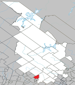 Location within Matawinie RCM | |
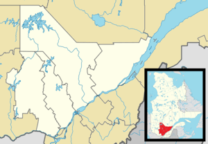 Entrelacs Location in central Quebec | |
| Coordinates: 46°07′N 74°00′W[1] | |
| Country | |
| Province | |
| Region | Lanaudière |
| RCM | Matawinie |
| Settled | 1840 |
| Constituted | January 1, 1860 |
| Government | |
| • Mayor | Sylvain Breton |
| • Federal riding | Joliette |
| • Prov. riding | Bertrand |
| Area | |
| • Total | 56.40 km2 (21.78 sq mi) |
| • Land | 48.06 km2 (18.56 sq mi) |
| Population (2011)[3] | |
| • Total | 906 |
| • Density | 18.9/km2 (49/sq mi) |
| • Pop 2006-2011 | |
| • Dwellings | 1,015 |
| Time zone | UTC−5 (EST) |
| • Summer (DST) | UTC−4 (EDT) |
| Postal code(s) | J0T 2E0 |
| Area code(s) | 450 and 579 |
| Highways | |
| Website | www |
Prior to February 13, 1991, it was in Les Pays-d'en-Haut Regional County Municipality in the Laurentides region.[4]
History
The area is part of the geographic township of Wexford, named after a town and county in Ireland, and first settled by Irish colonists circa 1840. In 1860, the Township Municipality of Wexford was established.[1]
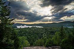
In 1967, it was decided to change the name to Entrelacs, meaning "between lakes" in reference to its position between Lakes Patrick and Des Îles. This name had already been used to identify the post office since 1889, but which closed in 1974.[1]
Demographics
Population
| Year | Pop. | ±% |
|---|---|---|
| 1991 | 628 | — |
| 1996 | 732 | +16.6% |
| 2001 | 798 | +9.0% |
| 2006 | 952 | +19.3% |
| 2011 | 906 | −4.8% |
Private dwellings occupied by usual residents: 471 (total dwellings: 1015)
Language
Mother tongue:[6]
- English as first language: 3.7%
- French as first language: 93.2%
- English and French as first language: 0%
- Other as first language: 3.2%
Education
Commission scolaire des Samares operates French-language public schools:
- École Notre-Dame-de-la-Merci — Saint-Émile (pavillon Saint-Émile)[7]
Sir Wilfrid Laurier School Board operates English-language public schools:
- Rawdon Elementary School in Rawdon (serves all of the city)[8]
- Saint Adèle Elementary School in Saint-Adèle (serves a portion)[9]
- Joliette High School in Joliette (serves all of the city)[10]
See also
References
- "Entrelacs (Municipalité)" (in French). Commission de toponymie du Québec. Retrieved 2009-11-25.
- Geographic code 62053 in the official Répertoire des municipalités (in French)
- Statistics Canada 2011 Census - Entrelacs census profile
- "Archived copy" (PDF). Archived from the original (PDF) on 2012-04-18. Retrieved 2012-05-18.CS1 maint: archived copy as title (link)
- Statistics Canada: 1996, 2001, 2006, 2011 census
- Statistics Canada 2006 Census - Entrelacs community profile
- "Notre-Dame-de-la-Merci — Saint-Émile (pavillon Saint-Émile)." Commission scolaire des Samares. Retrieved on September 23, 2017.
- "Rawdon Elementary" Zone Map. Sir Wilfrid Laurier School Board. Retrieved on September 17, 2017.
- "SAINTE ADÈLE ELEMENTARY ZONE." Sir Wilfrid Laurier School Board. Retrieved on September 16, 2017.
- "Joliette High School Zone Sec 1-5." Sir Wilfrid Laurier School Board. Retrieved on September 5, 2017.
| Wikimedia Commons has media related to Entrelacs, Quebec. |
Adjacent Municipal Subdivisions | ||||||||||
|---|---|---|---|---|---|---|---|---|---|---|
| ||||||||||
| Municipalities |
|
|---|---|
| Parishes | |
| Unorganized Territories | |
| |
| Authority control |
|
|---|