Empire Township, Ellsworth County, Kansas
Empire Township is a township in Ellsworth County, Kansas, USA. As of the 2000 census, its population was 174.
Empire Township | |
|---|---|
 Location in Ellsworth County | |
| Coordinates: 38°39′12″N 098°02′09″W | |
| Country | United States |
| State | Kansas |
| County | Ellsworth |
| Area | |
| • Total | 71.81 sq mi (185.98 km2) |
| • Land | 66.21 sq mi (171.49 km2) |
| • Water | 5.59 sq mi (14.49 km2) 7.79% |
| Elevation | 1,506 ft (459 m) |
| Population (2000) | |
| • Total | 174 |
| • Density | 2.6/sq mi (1/km2) |
| GNIS feature ID | 0475469 |
Geography
Empire Township covers an area of 71.81 square miles (186.0 km2) and contains no incorporated settlements. According to the USGS, it contains two cemeteries: Buckeye and Scates.
The streams of Alum Creek, Bluff Creek, Clear Creek, Sand Creek, Skunk Creek and Thompson Creek run through this township.
Transportation
Empire Township contains one airport or landing strip, Kanopolis State Park Airport.
gollark: Again: You're worried about your browsing history and stuff going to *everyone*. So presumably you recognize that disclosure of it could cause problems. But you assume google won't cause those problems? Why?
gollark: Consider. You're worried about your browsing history and stuff going to *everyone*. So presumably you recognize that disclosure of it could cause problems. But you assume google won't cause those problems?
gollark: As long as it's profitable.
gollark: Well, they can't really *publish* it publicly, but they totally can do other evil stuff with it!
gollark: What? Why is that BETTER?
External links
Municipalities and communities of Ellsworth County, Kansas, United States | ||
|---|---|---|
| Cities | 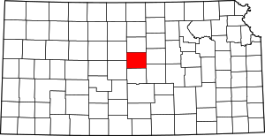 Map of Kansas highlighting Ellsworth County | |
| Unincorporated communities | ||
| Ghost towns | ||
| Townships | ||
| POIs | ||
This article is issued from Wikipedia. The text is licensed under Creative Commons - Attribution - Sharealike. Additional terms may apply for the media files.