Ellerton and Aughton
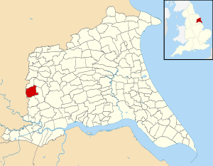
Ellerton and Aughton is a civil parish in the East Riding of Yorkshire, England. It is situated 12 miles (19 km) to the west of Hull city centre and covering an area of 1,824.551 hectares (4,508.56 acres).[2]
| Ellerton and Aughton | |
|---|---|
| Civil parish | |
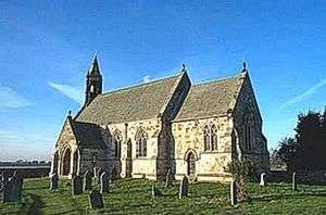
 St Mary's Church, Ellerton | |
 | |
| Population | 388 (2011 census)[1] |
| OS grid reference | SE707389 |
| Civil parish |
|
| Unitary authority | |
| Ceremonial county | |
| Region | |
| Country | England |
| Sovereign state | United Kingdom |
| Post town | YORK |
| Postcode district | YO42 |
| Dialling code | 01757 |
| Police | Humberside |
| Fire | Humberside |
| Ambulance | Yorkshire |
| UK Parliament | |
The civil parish consists of the villages of Ellerton and Aughton. It was formed as Ellerton parish in 1935, when the civil parishes of Ellerton Priory and Aughton were abolished and merged.[3] More recently, the parish of Ellerton was renamed Ellerton and Aughton.
According to the 2011 UK census, Ellerton and Aughton parish had a population of 388,[1] an increase on the 2001 UK census figure of 355.[4]
References
- UK Census (2011). "Local Area Report – Ellerton Parish (1170211173)". Nomis. Office for National Statistics. Retrieved 17 February 2018.
- "2001 Census Area Profile" (PDF). East Riding of Yorkshire Council. 2004. Archived (PDF) from the original on 18 March 2012. Retrieved 8 February 2013.
- Great Britain Historical GIS / University of Portsmouth, Ellerton CP. Retrieved 28 April 2020.
- UK Census (2001). "Local Area Report – Ellerton Parish (1543504219)". Nomis. Office for National Statistics. Retrieved 12 March 2008.
- Gazetteer — A–Z of Towns Villages and Hamlets. East Riding of Yorkshire Council. 2006. pp. 3, 5.
External links
![]()
- Aughton One-Place Study website - family and/or local history
- Ellerton One-Place Study website - family and/or local history
This article is issued from Wikipedia. The text is licensed under Creative Commons - Attribution - Sharealike. Additional terms may apply for the media files.