Elizabeth railway station
Elizabeth railway station is located on the Gawler line.[1] Situated on the border of the northern Adelaide suburbs of Elizabeth and Edinburgh, it is 25.8 kilometres (16.0 mi) from Adelaide station.
Elizabeth Interchange | |||||||||||
|---|---|---|---|---|---|---|---|---|---|---|---|
 | |||||||||||
| Location | Mountbatten Square Elizabeth | ||||||||||
| Line(s) | Gawler Line | ||||||||||
| Distance | 25.8 km from Adelaide | ||||||||||
| Platforms | 2 | ||||||||||
| Construction | |||||||||||
| Parking | Yes | ||||||||||
| Bicycle facilities | Yes | ||||||||||
| History | |||||||||||
| Opened | 1960 | ||||||||||
| Rebuilt | 1999 & 2012 | ||||||||||
| Services | |||||||||||
| |||||||||||
History
Elizabeth station opened in 1960.
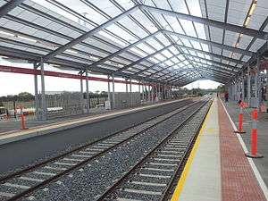
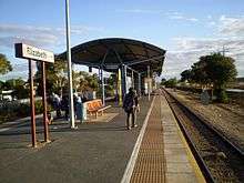
It was first rebuilt in 1999 with one island platform that was accessible by an underground pedestrian subway, and included a 40–50 metre roof. In March 2012, the station was rebuilt in a $15 million project. The work involved demolition of the island platform, construction of two side platforms, the track was re-aligned, and other changes were made in preparation for the electrification of the Gawler Central line in 2021.[2][3][4][5][6][7] As some peak-hour services were to terminate at Elizabeth, the rebuild included the addition of a siding just north of the station to allow trains to stable clear of the main line. The western platform is accessed both by a level crossing and an overpass; the level crossing is used for emergencies only.
Services by platform
| Platform | Destination/s |
|---|---|
| 1 | Gawler/Gawler Central |
| 2 | Adelaide |
Transport links
| Bus Transfers: Stop Stand A (Elizabeth Station) | |
| Route No. | Destination & Route Details |
| 440 | Munno Para station via Smithfield Interchange & Hamblyn Road[8] |
| 441 | Smithfield Interchange via Yorketown Road[9] |
| 442 | Smithfield Interchange via Blair Park Drive[10] |
| 443 | Elizabeth North Loop via Smithfield Interchange & Munno Para Loop[11] |
| Bus Transfers: Stop Stand B (Elizabeth Station) | |
| Route No. | Destination & Route Details |
| 451 | Munno Para Shopping Centre via Andrews Farm, Davoren Park & Smithfield Interchange and Curtis Road [12] |
| 452 | Munno Para Shopping Centre via Mark Oliphant College[13] |
| 900 | Salisbury Interchange via Peachey Road, Virginia & Waterloo Corner Road[14] |
| Bus Transfers: Stop Stand C (Elizabeth Station) | |
| Route No. | Destination & Route Details |
| 400 | Salisbury North via Salisbury Interchange[15] |
| 430 | Salisbury Interchange & Main North Road[16] |
| 224 | City via Salisbury Interchange & Mawson Interchange[17] |
| 560 | Tea Tree Plaza Interchange[18] |
| Bus Transfers: Stop Stand D (Elizabeth Station) | |
| Route No. | Destination & Route Details |
| C1 | City via O-Bahn, limited stop service[19] |
| 500 | City via Salisbury Interchange, Bridge Road & O-Bahn Transit Link limited stop service[20] |
Gallery
 Station before the 2012 upgrade
 Artist's impression of the new station
 Artist's impression of the new station
References
- Gawler Central timetable Archived 10 February 2014 at the Wayback Machine Adelaide Metro 4 February 2013
- Major upgrades to revamp Northern suburbs rail travel Anthony Albanese MP
- Elizabeth station upgrade Archived 30 March 2015 at the Wayback Machine Knox Constructions
- Elizabeth Station Upgrade York Civil
- Stations Upgrade Program Archived 17 February 2012 at the Wayback Machine Department of Planning, Transport & Infrastructure
- Federal Government pulls plug on $76m Gawler Line electrification Adelaide Advertiser 24 October 2013
- Langenberg, Adam (13 July 2018). "$615m Gawler electrification deal signed". The Advertiser. Adelaide. Retrieved 16 July 2018.
- Route 440 Adelaide Metro
- Route 441 Adelaide Metro
- Route 442 Adelaide Metro
- Route 443 Adelaide Metro
- Route 451 Adelaide Metro
- Route 452 Adelaide Metro
- Route 900 Adelaide Metro
- Route 400 Adelaide Metro
- Route 430 Adelaide Metro
- Route 224 Adelaide Metro
- Route 560 Adelaide Metro
- Route C1 Adelaide Metro
- Route 500 Adelaide Metro
External links

- Flick gallery