El Rito Formation
The El Rito Formation is a geologic formation in New Mexico dating to the Eocene epoch.
| El Rito Formation Stratigraphic range: Eocene | |
|---|---|
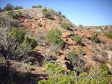 El Rito Formation near Arroyo del Cobre, New Mexico | |
| Type | Formation |
| Underlies | Ritito Conglomerate |
| Overlies | Morrison Formation, Dakota Formation |
| Thickness | 70 m (230 ft) |
| Lithology | |
| Primary | Sandstone |
| Other | Mudstone |
| Location | |
| Coordinates | 36.276°N 106.302°W |
| Region | New Mexico |
| Country | United States |
| Type section | |
| Named for | El Rito Creek |
| Named by | H.T.U. Smith |
| Year defined | 1938 |
 El Rito Formation (the United States)  El Rito Formation (New Mexico) | |
Description
The formation is composed of brick-red well-consolidated sandstone, conglomerate, and breccia. The pebbles are predominantly quartzite, with no volcaniclastics. It crops out over a narrow belt from the southern Tusas Mountains[1] to upper Coyote Creek.[2] In the southern Tusas Mountains, it fills narrow paleovalleys eroded in basement quartzite. Further south, the rock grades from heterogeneous breccia to a poorly sorted conglomerate. The breccia is interpreted as regolith and talus, while the conglomerate is interpreted as a high-energy stream deposit. The distinctive red color is found penetrating joints in the underlying quartzite to depths of several meters. Further south and west, the formation transitions to lighter-colored sandstone. Maximum thickness is 70 meters (230 feet).[1] A characteristic feature of the sandstone is the presence of muscovite.[2]
The base of the formation is an angular unconformity with much older beds of Jurassic to Cretaceous age, while the upper contact is an erosional disconformity with the Abiquiu Formation.[1][2]
Age control is poor due to an almost complete lack of fossils. However, the formation was deposited in the waning phase of the Laramide orogeny under arid conditions. Paleocurrents and conglomerate clast provenance show that the source region was the Brazos uplift to the north and northeast. The formation was deposited in an asymmetrical basin formed in response to compression of the Laramide orogeny,[3] truncated to the west along the Canones fault zone.[4] The El Rito basin likely was continuous with the Galisteo Basin before the opening of the Rio Grande rift separated the two basins starting in the Miocene. The El Rito Formation thus likely correlates with the Diamond Tail and Galisteo Formations.[3]
History of investigation
The formation was named in 1938 by Harold T.U. Smith for exposures along El Rito Creek.[1]
Footnots
- Smith 1938
- Lawrence et al. 2004
- Logsdon 1981
- Kelly et al. 2013, p.118
References
- Lawrence, R., Kelley, S. A., and Rampey, M., 2004, Preliminary geologic map of the Cerro del Grant 7.5-minute quadrangle, Rio Arriba and Sandoval Counties, New Mexico: New Mexico Bureau of Geology and Mineral Resources, Open-file Geologic Map 87, scale 1:24,000.
- Kelley, S.A., Kempter, K.A., McIntosh, W.C., Maldonado, F., Smith, G.A., Connell, S.D., Koning, D.J., and Whiteis, J., 2013, Syndepositional deformation and provenance of Oligocene to Lower Miocene sedimentary rocks along the western margin of the Rio Granderift, Jemez Mountains, New Mexico, in Hudson, M.R., and Grauch, V.J.S., eds., New Perspectives on Rio Grande Rift Basins: From Tectonics to Groundwater: Geological Society of America Special Paper 494, doi:10.1130/2013.2494(05).
- LOGSDON, MARK J. (1981). "A preliminary basin analysis of the El Rito Formation (Eocene), north-central New Mexico". Geological Society of America Bulletin. 92 (12): 968. doi:10.1130/0016-7606(1981)92<968:APBAOT>2.0.CO;2.
- Smith, H.T.U., 1938, Tertiary geology of the Abiquiu quadrangle, New Mexico: Journal of Geology, v. 46, no. 7, p. 933-965.